See our right-hand column for announcements and news briefs. Scroll down the right-hand column to access the Archives -- links to articles posted in the main column since 2007. See details about our site, including a way to comment, in the yellow text above the Archives.
Showing posts with label Michigan DNR. Show all posts

Friday, December 30, 2022

Guest article: Michigan's latest 2022 Wolf Management Plan

By Nancy Warren, Executive Director and Great Lakes Regional Director, National Wolfwatcher Coalition

Western Upper Peninsula wolf. Note the collar and red ear tag in right ear indicating she was collared in Michigan. Click on photo for larger version.

In order to understand the latest updated Wolf Management Plan for Michigan, you may wish to review these Fast Facts:

  • Federal protections, under the Endangered Species Act, were restored on February 10, 2022, for wolves in most of the US, including Michigan. Wolves in those states covered by the court order cannot be killed for any reason except defense of human life.

  • In 2011, wolves in Montana, Idaho, Washington, Oregon and Utah lost their federal protections when a rider was attached to a "must-pass" federal budget bill. However, due to the egregious hunting and trapping practices in the Northern Rockies, a formal petition was filed by many conservation groups, including the National Wolfwatcher Coalition, to restore protections. A decision by US Fish and Wildlife Services is expected soon.

  • The Michigan wolf population has remained stable for more than 12 years -- between 600 and 700 wolves. No wolves have been detected in the Lower Peninsula.

  • Michigan’s UP has about 1,000 working farms, with 50,000 head of cattle. In 2022, only three farms experienced a conflict with wolves and only one farm experienced more than one event. Six calves were killed.

  • Producers were reimbursed the fair market value for those animals killed as determined by the Michigan Department of Agriculture. Total amount paid was $3357.

  • The low number of conflicts is consistent with prior years with only a handful of farms experiencing a conflict.

  • Wolf-Dog conflicts are also low and consistently involve hunting dogs in pursuit of game such as bear, bobcat and hare.

  • Upon delisting, livestock producers and dog owners can use lethal control if a wolf is "in the act" of attacking their animals; livestock producers can also be issued permits to use licensed hunters to kill wolves at chronic farms.

  • Weather -- not wolves -- has the greatest impact on deer populations. Research shows that in the UP, nearly 70 percent of the wolf predations of adult does occurred in the late winter and spring months when body condition of deer was at its poorest. Further investigation into the body condition of adult does killed by wolves in the high snowfall zone found that nearly half (43 percent) were in extremely poor nutritional condition and likely would not have survived the winter even if they were not preyed upon.

  • Before a wolf hunting and trapping season can take place, wolves need to be federally delisted. Then, DNR must engage in tribal consultations and consider input from stakeholders, department biologists, and the general public. Ultimately, the Natural Resources Commission will decide whether a hunting/trapping season will occur.

2022 Wolf Management Plan Update

Having served on the council for developing the guiding principles for the 2008 and 2015 plan updates, I understand what must be considered in a wolf management plan. Do wolves even need to be managed? There are different interpretations of what it means to "manage" wolves. There are competing values. Some believe the only good wolf is a dead one; others believe no wolf should be killed for any reason.  Some question the ethics of collaring wolves. Fortunately, those extremes represent a very small minority.

What role should politics, lawsuits and the media play?

We learn more and more about wolves as evidenced by the more than 100 new scientific citations referenced in this updated plan. There is still so much more to learn. GPS collars and other technology have given us insight into pack dynamics, territory size, dispersal and mortality.

There is a role playing exercise I do with high school students with each team studying the position of a different stakeholder -- including the farmer who lost livestock to wolves, the hunter, the biologist, the politician, the Native American, the "protectionist," etc. Then a stuffed wolf is placed on a ring with cords attached to it while each student holds a piece of cord.  They are tasked with lifting the wolf and walking with it and balancing the wolf and ring on a ball which moves. If one side pulls too hard, the wolf falls.

In this role playing exercise students learn how stakeholders need to work together to balance wolf management. (Photo courtesy Nancy Warren)

Wolf management is a balancing act. Michigan wolves do not live in isolation. They do not understand state boundaries. We all need to work together for the wolf to survive and thrive in Michigan and elsewhere.

I believe the updated 2022 Michigan Wolf Management Plan, which was recently signed, accomplishes that goal.

Consistent with the 2008 and 2015 plans, the update provides guiding principles for wolf management and utilizes the most current biological and social science complied in the White Paper  "Review of Social and Biological Science Relevant to Wolf Management in Michigan."

The four goals remain the same as described in the earlier plans:
•    Maintain a viable population
•    Facilitate wolf-related benefits
•    Minimize wolf-related conflicts
•    Conduct science-based and socially responsible management.

Also unchanged, the update does not identify a target population size, nor does it establish an upper limit for the number of wolves in Michigan.

The plan also recognizes the cultural and religious values regarding wolves important to many Native Americans.

In general, statewide, public attitudes towards wolves have improved since the 2006 Survey.

The present Wolf Management Plan indicates the estimated percentage of people who desire a reduced wolf population is 24.0 percent while 49.9 percent desire an increase.

Majority of respondents do not support killing wolves in the event of wolves killing a pet, hunting dog or livestock; only 35 percent support lethal control to address predation on livestock, even less for hunting dogs and pets.

Statewide, less than half support a wolf hunting season (down from the 2015 survey).  70.2 percent of the general public strongly or moderately agreed that wolves are an important part of ecosystems. 80.2 percent strongly, moderately, or somewhat agree that wolves have an inherent right to exist. 49.9 percent desire an increase in the wolf population (24 percent prefer fewer). Support for compensation for livestock producers declined, only 48.5 percent indicated it was somewhat, moderately, or highly acceptable to use tax dollars for compensation (2015, 58 percent).

49.2 percent of state residents support and 30.4 percent oppose a legal, recreational hunting season for wolves, if biologists and the DNR believed the wolf population could sustain it.

2022 Plan Highlights

The Plan places a strong emphasis on the need for education and stresses the importance of non-lethal measures to resolve wolf conflicts.

It states, "To the extent non-lethal methods are effective at eliminating or minimizing depredation problems, lethal control of wolves will not be necessary. However, when such practices prove to be ineffective, are not expected to be effective, or are infeasible, lethal control may be necessary to prevent problems.
 
"Lethal control will be a management option in situations where loss of livestock has been documented or where a wolf is in the act of depredating livestock; it will not be used as a preventative measure in areas where livestock depredation has not yet occurred."

Western Upper Peninsula wolf.

Some groups, lawmakers and even members of the Natural Resources Commission have often incorrectly interpreted the definition of a "viable" population of wolves, even though the prior plans clearly stated 200 wolves is not a target population size. Therefore, the updated plan further defines a viable population by explaining wolves are "an integral part of the natural resources of the State and are a component of naturally functioning Michigan ecosystems. In the context of the DNR’s mission and its implicit public trust responsibilities for the State’s wildlife, natural communities and ecosystems, the maintenance of a viable wolf population is an appropriate and necessary goal."

The Plan does not oppose or support a wolf hunting season.  Rather, it addresses under what circumstances a hunt may take place for the purpose of reducing conflicts versus a recreational hunt.

For addressing conflicts through the use of hunters and trappers, the plan states, "If it is determined that the number of conflicts are correlated to wolf abundance, or the spatial extent of the conflicts indicate it involves multiple pack territories, it may warrant the consideration of reducing wolf numbers in areas that span multiple pack territories to reduce the risk of future conflicts. Such consideration could be necessary if a high density of wolves in an area, rather than the behavior of individual wolves, is determined to be responsible for problems that could not otherwise be addressed through non-lethal or individually directed lethal method."  Further, it explains, "There is scientific uncertainty relative to the use of wolf harvest as a conflict management tool because most wildlife managers do not have experience with this approach for wolves."

When considering a wolf hunting / trapping season for recreational purposes, the DNR is committed to evaluating the biological effects of a season and public attitudes. The plan states, "If biologically sustainable, legally feasible, and socially responsible, develop recommendations to the NRC to offer opportunities for the public to harvest wolves for recreational purposes."

To address ecological, social, and regulatory shifts in a timely manner, the DNR will review and update this plan at 10-year intervals.

The wolf management plan is 74 pages (plus appendices and cited references). I highlighted just a few of the most controversial aspects of wolf management. If you have any questions, do not hesitate to contact me at nancy@wolfwatcher.org

Editor's Note: For more information and news from the National Wolfwatcher Coalition, visit their Web site: https://wolfwatcher.org/

Sunday, March 07, 2021

KORC: Community Action for Permanent Public Land

By Nicholas Wilson*
With photos by guest photographers

Mountain biker Ben Ciavola rides the "On The Edge" trail along the Brockway Mountain ridge. Click on photo for larger version. (Photo © and courtesy Nathan Miller)

The Keweenaw Outdoor Recreation Coalition (or KORC for short) has attracted public interest from Keweenaw residents and outdoor enthusiasts of all kinds. You may have received a KORC letter in the mail, seen social media content on Facebook or Twitter, or heard about the group’s work at High Rock Bay and Schlatter Lake. So, what is this organization all about?

KORC was founded in 2019 when a coalition of community organizations, local businesses, outdoor recreation interests, and Keweenaw residents came together to pursue a common goal: securing permanent public access to at-risk land in Keweenaw County.

With over 600 members and more than 15 different organizations represented on its steering committee, KORC has united a wide variety of recreation interests and Keweenaw institutions.

"We all decided to get together and develop a coalition to provide for all types of outdoor recreation, where all of the different voices are represented," said Gina Nicholas, a member of KORC’s Steering Committee. "We are working together to keep the land base intact for everyone, so that whether you’re a berry picker or an ATV rider, you have a place to go." Inset photos: At left, a midsummer snack of bilberries along the Copper Harbor Trails. (Photo © and courtesy Devin Leonarduzzi) At right, ORV riders enjoy Keweenaw’s fall color. (Photo © and courtesy Nathan Miller)

KORC’s recreation interests range from self-powered activities like hiking, camping, biking, kayaking, skiing, and snowshoeing, to motorized sports like ATV/ORV riding and snowmobiling. KORC also represents hunting, fishing, berry-picking, and bird watching as well as environmental, geological, historical, and cultural heritage interests. KORC wants to secure permanent public access and provide land use opportunities for all of these varied interests.

KORC Steering Committee member and Eagle Harbor Township Supervisor Rich Probst described the importance of this coordinated effort.

"The biggest thing is the collaboration with all the groups," Probst said. "We are all in this together, getting it done with everybody’s input for the good of the whole."

KORC members are working together to secure land access because much of Keweenaw’s real estate is at risk to fragmentation and loss of public access. Today, a significant portion of the land in Keweenaw County is controlled by an absentee corporate owner.

During the Keweenaw’s copper mining boom in the late 1800s and early 1900s, mining companies amassed ownership of the majority of the land in Keweenaw County. Over time, these companies and the land that they controlled were consolidated under the Calumet and Hecla mining company. But as the industry declined and the mines closed in the latter half of the 20th century, Calumet and Hecla and other mining companies sold off their land.

Since then, this Keweenaw land has changed hands between a string of corporate owners who buy and sell the land as an asset for timber harvest and value appreciation. Today, approximately 120,000 acres of Keweenaw land are owned by the New York based hedge fund complex, The Rohatyn Group (TRG), and overseen by a land management consulting firm called American Forest Management (AFM). Prior to TRG, most of Keweenaw County’s land was owned by another international hedge fund complex, GMO (Grantham, Mayo, Van Otterloo and Co., LLC). GMO is the name that appears in the most recent plat book.

Because this land has mostly been controlled by one owner at a time, much of it has remained intact with largely uninhibited public access. But although TRG and its predecessors have generally been tolerant of public recreational access, they care little for the land’s well-being (other than the return on investment it generates) and do not guarantee that the public will always be able to enjoy it. TRG holdings are often aggressively harvested for timber, sometimes to the detriment of the native ecosystem and land quality. Logging also disrupts the trail systems and roads that provide access to remote areas. Inset photo: Keweenaw deer hunters. (Photo © and courtesy Gina Nicholas)

The biggest risk to public access on this land is fragmentation. Hedge funds are almost always ready to sell parts of their holdings for the right price. If pieces of TRG’s holding are sold, and the land is sectioned off into pieces controlled by many private owners, public use may be restricted, trail systems may be forced to re-route or be removed entirely, and Keweenaw residents could lose access to land that they have enjoyed for generations.

Fragmentation is already occurring. In 2000, a forest products company called International Paper owned approximately 175,000 acres of Keweenaw County land. Today, only 120,000 acres of this land are still controlled by a single corporate owner (presently TRG). The difference between these two figures, 55,000 acres of Keweenaw land, has been sectioned off and sold by hedge fund owners over the past two decades. While some of this land was purchased by local conservancies and units of government and is still open to the public, some prime lakeshore properties and other desirable areas have been sold to private owners and are now developed or inaccessible to the public.

Skiers and snowshoers trek up Mount Baldy. (Photo © and courtesy Nathan Miller) 

"We had the privilege for almost 100 years of using this land that we didn’t own and we didn’t pay taxes on -- we just used it because the owners didn’t care," Nicholas noted. "But it wasn’t a right; it was always a privilege. We can’t rely on privileges any longer. We have to find a way to secure access in a legal and respectful manner."

Working with Michigan DNR

KORC hopes to secure this access by collaborating with the State of Michigan to help manage existing State land and to assist the State in acquiring more Keweenaw County land.

In 2002-2003, the State of Michigan purchased roughly 6,300 acres of land on the tip of Keweenaw using money from the Michigan Natural Resources Trust Fund. The initial Tip purchase was made possible with help from The Nature Conservancy (TNC). Over time, TNC, Keweenaw Community Forest Company, and other organizations have helped the Michigan DNR (Department of Natural Resources) add additional parcels and eliminate inholdings. Today the DNR owns 8,999 acres at the Keweenaw Tip and 822 acres at Fort Wilkins.

Dana Richter photographed this view of Manitou Island from High Rock Bay in 2004 during a tour with members of the Keweenaw Point Advisory Committee and DNR staff, following the initial Keweenaw Tip purchase. Remains of a campfire can be seen in the foreground. (Keweenaw Now file photo © 2004 Dana Richter. Reprinted with permission.) 

In 2005, representatives from the community collaborated with the DNR to produce a management plan for this land. But in the years since, management and stewardship actions have been limited. Visitors to the Keweenaw Tip land are increasingly impeded by poor roads, and they often find these beautiful places damaged by garbage dumping and other misuse.

Community partnerships for management

"The land has huge recreational value and potential, but it is underutilized and undermanaged," noted Aaron Rogers, owner and president of Rock Solid Trail Contracting and a KORC Steering Committee member. "The only way to improve management is with more community involvement. We can do this locally -- not only by advocating for the purchase of more land, but by actively helping to manage it ourselves." 

A smiling woman mountain biker heads down one of the Keweenaw's challenging trails. (Photo © and courtesy Nathan Miller)

In the spring of 2020, KORC representatives began working together with the DNR to improve public access and clean up this land. KORC and its partner organizations purchased and installed bear-proof trash receptacles at High Rock Bay, and will be funding and constructing a vault toilet to be installed at High Rock in 2021. KORC will provide services for trash collection and vault toilet maintenance by funding partners with local employees.

Trash receptacle installed at High Rock Bay in the summer of 2020. (Photo © and courtesy Gina Nicholas) 

KORC also raised money to improve the West Schlatter Lake Road. During the summer of 2020, KORC members raised funds to retain Mike McMahon through JE Hendrickson Excavating to repair the road, enabling safer public access for camping and other recreation at Schlatter Lake. KORC also helped Keweenaw County raise money to improve amenities at the Gratiot River Park in Allouez Township. 

Summer camping at High Rock Bay. (Photo © and courtesy Jim Vivian III)

"I see KORC as a mechanism to allow all the local interest groups to work together to utilize this land," said Mark Ahlborn, Calumet Keweenaw Sportsmen’s Club member and KORC Steering Committee member. "It’s how we are all going to get together to serve everyone who wants to come and visit us."

Businesses and tourism economy

KORC members also believe taking care of Keweenaw’s land and providing positive experiences for visitors are crucial for the local economy. Many of Keweenaw’s restaurants, hotels, shops, and other local businesses depend upon tourism revenue. Visitors are drawn to the Keweenaw for a variety of reasons, from the area’s unique geological features to its mountain biking trails. But these features, and the tourists that they attract, are dependent upon wise management and sustained public access to Keweenaw land.

"Historically we’ve always had it -- it’s always been viewed as a recreational asset for the community, not only for personal use but for tourism and generating tourism dollars for the region," said Rogers. "If it gets sold off and it disappears, it will have a significant impact on tourism and the local economy."

Runners race along the Point Trail during the Run the Keweenaw event. (Photo © and courtesy Nathan Miller)

Don Kauppi, KORC Steering Committee member and co-owner of The Mariner North in Copper Harbor, reflected on the economic impact of Keweenaw’s growing tourism industry. Since the 1970s, tourism-based jobs in the Keweenaw have increased dramatically, largely due to outdoor recreational attractions like snowmobiling and biking. Don explains that despite little change in the year-round populations of Houghton and Keweenaw counties, today there are 35 more restaurants in the two-county area than there were in 1978.

A snowmobiler traverses the rugged terrain. (Photo © and courtesy Rich Probst)

Don also described how the recently growing interest in outdoor recreation during all four seasons has extended the months of profitable tourism business in Copper Harbor.

"The terrain is our product," he said. "Now, we’re going to try to save Keweenaw jobs by saving the terrain that brings people up here."

For many KORC members, protecting the local economy means protecting a way of life.

Steering Committee member Jim Vivian III points out that 70 percent of Keweenaw jobs are tourism-based.

"If we lose access to the land, I think it will take decades for our local economy to recalibrate," Vivian said. "It’s to protect our way of life and our economy."

For Keweenaw business owners, promoting the area’s economic vitality goes hand in hand with protecting land and securing public access.

"KORC represents an underlying goal of why I got into business 20 years ago," explained Sam Raymond, Steering Committee member and the owner of Keweenaw Adventure Company. "I thought that trails and outdoor recreation could result in the preservation of the Keweenaw for permanent public access and utilization of all of the wonderful resources that we have. KORC is the vehicle to get us there right now."

Kayaking in blue Lake Superior Waters. (Photo © and courtesy Chris Guibert)

KORC seeks public support for State land ownership

KORC is now supporting the DNR’s effort to acquire approximately 15,800 acres of additional land by using the Michigan Natural Resources Trust Fund or other methods to bring this acreage into permanent State ownership. This land includes the actual geographic Keweenaw Point, much of the Mandan road, and portions of the motorized trail system.

If the State purchases this land, it will ensure permanent public access for all to the "Keweenaw Tip Recreation Area." It will secure the main motorized trail corridor ("the rail road grade") from Mohawk to the Tip, and could expand trail systems and other outdoor recreation opportunities. This acquisition would also connect the ecosystems found on the Tip to the larger Keweenaw Coastal Wildlife Corridor by linking the Tip to township and conservancy lands along the Brockway Mountain ridge to Eagle Harbor and Eagle River.

This map shows the potential Keweenaw Tip Recreation Area that State land acquisition would allow. Click on map for larger version. (Map courtesy KORC)

KORC is conducting outreach using mailings, email blasts, and social media to raise awareness and gain public support for this project. Additionally, KORC has collaborated with the Keweenaw County Road Commission to collect data on public use of the Mandan Road from the end of US 41 in order to help build the case for land acquisition. KORC encourages anyone who supports this acquisition to submit a nomination form either electronically or through the mail to tell the State why acquiring this land is important.

"Over the years the State never really had the chance to see what we have to offer up here, but now I think that we can prove to them that we are such an asset," said Peg Kauppi, Steering Committee member and co-owner of the Mariner North. "Here we are with this unreal piece of real estate that juts out into Lake Superior. We have so much to offer: the largest vertical drop east of the Rockies, the wildflowers, the rocks, it goes on and on."

Brockway Mountain Summit west vista, showing Lake Superior and Keweenaw Coastal Wildlife Corridor, Eagle Harbor Township. A Michigan Natural Resources Trust Fund grant allowed Eagle Harbor Township to acquire the Brockway summit in 2012. That purchase added to the Keweenaw Coastal Wildlife Corridor for conservation and recreational access.(Keweenaw Now file photo courtesy Eagle Harbor Township)

"I think that if we don’t take control of this property now so that it can’t be segmented off, then we lose that ability forever," Peg concluded.

KORC and its partners intend to keep working to secure access to Keweenaw land for outdoor recreation, for the local economy, for conservation, for Keweenaw’s cultural heritage. Their hope is that everyone can experience and enjoy this land forever. Gina Nicholas expressed this wish for future generations.

"I’ve always loved Keweenaw, and I want my child and my future grandchildren to have the same thing that I feel is one of the most important things in my life," Nicholas said. "I have to fight for posterity."

Aaron Rogers noted his belief that everyone who has a life in the Keweenaw region can support the KORC mission of securing public access to this land.

"I would encourage people -- if they have any questions about KORC, its mission, and what it stands for -- to reach out and gain an understanding of what we are trying to do," Rogers said. "All of our communities stand to benefit from what KORC is doing."

More information on KORC and its initiatives can be found on the KORC Website, and on KORC’s Facebook, Instagram, and Twitter pages. KORC encourages interested individuals to become members and support the group’s efforts to secure permanent public access to Keweenaw land.

* Editor's Note: Keweenaw Now guest writer Nicholas Wilson is a Keweenaw resident and free-lance journalist. 

Sunday, December 08, 2019

Michigan House Water Protection Package is legislation for our children, our traditions

Press Release from the Anishinaabek Caucus of Michigan Democratic Party

Michigan House Democratic leaders present their Water Protection Legislative Package of 2019 during a Dec. 5, 2019, press conference. Speakers in support of the bill package also include Anishinaabek Caucus and environmental group leaders. (Photo courtesy Anishinaabek Caucus of Michigan Democratic Party)

LANSING -- Anishinaabek Caucus of Michigan Democratic Party Founder and Chair Andrea Pierce and several Anishinaabek Caucus members were in attendance at the Michigan House press conference for the Water Protection Legislative Package of 2019. Yousef Rabhi (D-Ann Arbor), Laurie Pohutsky (D-Livonia) and Rachel Hood (D-Grand Rapids) are using legislation to affirm that all waters of Michigan are held in the public trust.

At a Dec. 5, 2019, Michigan House of Representatives press conference in Lansing, Michigan Democratic Party leaders present their Water Protection Legislative Package of 2019. The three-bill package affirms that all the waters of the state are held inalienably in the public trust, bans the diversion of bottled water outside the Great Lakes watershed and explicitly authorizes the Department of Natural Resources (DNR) to protect water in its jurisdiction. (YouTube video courtesy Michigan House Democrats)

Rabhi’s bill puts water resources into the public trust for the benefit of the people of Michigan.

"We need to manage our water responsibly for the benefit of the people of our state, instead of allowing it to be diverted, polluted or exploited for corporate profits," Rabhi said.

Pohutsky’s bill returns oversight for water resources to the Department of Natural Resources in the areas where the DNR exercises oversight for game and fish.

"Michigan’s wealth of freshwater is central to our culture, our economy and our very survival," noted Pohutsky.

Hood’s bill bans exportation of bottle water extracted in Michigan outside the Great Lakes Basin, thereby closing the small container loophole.

"We should not be allowing corporations to profit off of permanently removing massive quantities of the water that belongs to all of us," Hood said.

These bills recognize that surface and groundwater within the Great Lake Basin is a complex and connected single hydrological body that rightfully belongs to the people of Michigan for the benefit and sustenance of the people of Michigan.

Thunderbird Woman represents water protectors. (Image © Isaac Murdoch and courtesy Anishinaabek Caucus of Michigan Democratic Party)

"As water is essential to all living things, we can agree that water needs to be protected from exploitation," said Val Toops, Anishinaabek Caucus member and candidate for Jackson County Sheriff.

Andrea Pierce, chair of the Anishinaabek Caucus of the Michigan Democratic Party, urged all Michigan residents to call their state representatives and ask them to support the Water Protection Bill Package.

Anishinaabek Caucus members, from left, Val Toops, Andrea Pierce and Blackcrow. (Photo courtesy Anishinaabek Caucus)

"Advancing legislation to care for our water is one of the main reasons we have formed the Anishinaabek Caucus so that we can protect the culture and traditions of the original people of Michigan," Pierce explained. "We need to work for and protect the water and the land for the next seven generations."*

* Editor's Note: To learn more about the Anishinaabek Caucus of the Michigan Democratic Party visit their Facebook page or email
AnishinaabekCaucus@gmail.com.

Tuesday, March 13, 2018

Letter: Will mining in the Porkies ever be "safe"?

[Editor's Note: Keweenaw Now received the following letter in February in response to our Feb. 12, 2018, article on Highland Copper's mining exploration in the Porcupine Mountains Wilderness State Park, aka, the Porkies. See this featured article by clicking on the link in our right-hand column or click here. We regret the delay in posting this letter and other articles. Keweenaw Now's editor is experiencing temporary vision issues, making it difficult to post in a timely manner.]

Dear Editor,

The fact that the Mining Action Group of UPEC (Upper Peninsula Environmental Coalition) was consulted before the Feb. 6 press release by the DNR (Department of Natural Resources) is good news for the public and our environment. They and Highland Copper Co. representatives went to great lengths to assure us they would be on their best behavior this year. The company will have its engineer with the drilling subcontractor; the former, we were told, has the authority to stop drilling should weather conditions lead to thawing of the ground. The DNR said it would have its personnel regularly checking that no new harm comes to the Porkies.

However, I'm left wondering whether the recent press releases from the DNR have been carefully designed to prevent future blow back against the DNR, the state agency that manages the Porcupine Mountains Wilderness State Park. When these damages were first investigated and reported, the public responded with outrage -- drilling in the Porcupine Mountains Wilderness!? Everyone assumed that the Porkies were safe from mining activities -- unfortunately, that isn't true. Folks are shocked.

The Porcupine Mountains are iconic in the minds of Michigan citizens, but the DNR suggests that copper mines and wilderness areas are compatible. The message from DNR seems to be "Don't worry, the Porkies will retain a pristine surface even if Highland Copper Co. is blasting copper underneath the Park."

Is the DNR trying to convince the public that they want this mine? Mining impacts will include light pollution, mine waste, water quality concerns, vibrations, noise, dust, ore trucks, mine waste permanently stored along the shoreline of Lake Superior, and more. The Copperwood Mine would be across the road from the Porkies -- maybe literally underneath our hiking boots. Who wants that?

Horst Schmidt, President, Upper Peninsula Environmental Coalition

Friday, January 26, 2018

EPA task force to hold public meeting on saving Buffalo Reef Jan. 30 in Lake Linden

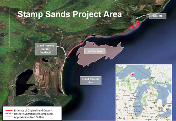
This map shows the area of the potential 2018 stamp sands project for additional stamp sand removal and containment near Gay on the Keweenaw Peninsula in Lake Superior. The project's main purpose is to save the trout and whitefish spawning areas on Buffalo Reef (center of map). Click on map for larger version. (Map courtesy Michigan DNR)

[Note: This Department of Natural Resources (DNR) news release is being issued in conjunction with the Michigan Department of Environmental Quality, the Keweenaw Bay Indian Community and the U.S. Army Corps of Engineers.]

A cooperative multi-entity task force created by the U.S. Environmental Protection Agency is reminding the public about a public meeting set for Tuesday, Jan. 30, in Lake Linden, on efforts to save the important lake trout and whitefish spawning areas on Buffalo Reef.

The underwater reef is threatened by shifting stamp sands, a by-product of copper milling done in the community of Gay, beginning in the early 1900s and lasting roughly 30 years.

The public meeting will be held from 6 p.m. - 8 p.m. Tuesday, Jan. 30, 2018, at the Lake Linden-Hubbell High School Auditorium, 601 Calumet Street in Lake Linden. A session previously scheduled for Dec. 5 was postponed due to inclement weather.

In addition to the Jan. 30 public meeting, an invitation-only Wednesday, Jan. 31, meeting on Buffalo Reef for EPA task force members and scientists has also been set. That session was previously scheduled for Dec. 6, but was canceled because of blizzard conditions.

The EPA formed the task force to develop a long-term plan over the next couple of years to contain and potentially reuse the stamp sands. The group will gather input from many stakeholders, including the public.

"We will be soliciting public input on what issues the plan needs to address and looking for volunteers to help us understand and resolve those issues," said Steve Casey, a task force member representing the Michigan Department of Environmental Quality.

Editor's Note: For background on this issue see our Nov. 21, 2017, article, "DNR stamp sand dredging buys time; EPA provides $3.1 million for Army Corps dredging to protect Buffalo Reef fish spawning habitat."

Tuesday, November 21, 2017

DNR stamp sand dredging buys time; EPA provides $3.1 million for Army Corps dredging to protect Buffalo Reef fish spawning habitat

By Michele Bourdieu, with information and photos from Michigan Dept. of Natural Resources

A tall stamp sand embankment and remains of a stamp mill dock on Lake Superior at Gay. (Photo courtesy Michigan Department of Natural Resources)

The Michigan Department of Natural Resources (DNR) recently completed an emergency dredging project in Keweenaw County to restore the Grand Traverse Harbor channel for commercial and recreational boating.

The $246,230 dredging project, undertaken by Marine Tech, LLC of Duluth, Minnesota, through the DNR’s Parks and Recreation Division, pumped 9,000 cubic yards of stamp sand -- mining waste from former stamp mills near Gay -- to a beach area north of the harbor.

The Grand Traverse Harbor shown in October, after the recent DNR dredging project and before a fall storm pushed stamp sands over a retaining barrier and into the Traverse River. (Photo courtesy Michigan DNR)

Meanwhile, more extensive stamp sand removal and containment efforts are needed to protect important lake trout and whitefish spawning habitat on Buffalo Reef and a juvenile whitefish area south of the Grand Traverse Harbor, which is situated on the east side of the Keweenaw Peninsula, northeast of Lake Linden. The US Army Corps of Engineers (USACE), the DNR and the Michigan Department of Environmental Quality (DEQ) are working on a new dredging project for 2018.*

This map shows the area of the potential 2018 stamp sands project for additional stamp sand removal and containment near Gay on the Keweenaw Peninsula in Lake Superior. Click on map for larger version. (Map courtesy Michigan DNR)*

"Buffalo Reef is a 2,200-acre spawning reef located down drift of stamp sands that have eroded into Lake Superior since the early 1900s," said Phil Schneeberger, DNR Fisheries Division Lake Superior Basin coordinator. "It is currently estimated that this reef, critical to both lake trout and lake whitefish populations in the area, is currently 35 percent unusable by spawning fish due to sand that has filled spaces between rocks, which are necessary for successful fish egg deposit and incubation. Furthermore, migrating sands along the shore have made nursery areas unusable by newly-hatched fish."

Charles Kerfoot, Michigan Tech professor in Biological Sciences and director of the Lake Superior Ecosystem Research Center, has worked with the Army Corps and the EPA on the stamp sands project. In 2014 he and several colleagues published an article on the stamp sands that are invading  Buffalo Reef. In that article, "Light Detection and Ranging (LiDAR) and Multispectral Scanner (MSS) Studies Examine Coastal Environments Influenced by Mining," published in ISPRS International Journal of Geo-Information, they state the following: "The biological effects of stamp sand encroachment could create several direct and indirect effects. The direct effects are toxic copper impacts on benthic algae, benthic invertebrates and fish. The indirect effects are physical, e.g., stamp sands filling in crevices in boulder fields, reducing the breeding field options and area. With beach seine samples, Bill Mattes (GLIFWC) has documented abundant lake whitefish fry along the white sandy beach, but none along the comparable stamp sand beach stretches. We suggest that whitefish (and all other species) are absent because copper kills benthic organisms (algae and invertebrates) directly, eliminating both invertebrates and their food (algae)."**

Kerfoot told Keweenaw Now he is now working with the Army Corps and DEQ on "long-term modeling and assessing environmental effects of migrating stamp sands in Grand (Big) Traverse Bay (Buffalo Reef, shoreline and rivers, lower bay) and Keweenaw Bay (fisheries)."

Nearly a quarter of the annual lake trout yield from Lake Superior’s Michigan waters comes from within 50 miles of Buffalo Reef. The Great Lakes Indian Fish and Wildlife Commission (GLIFWC) estimates the annual economic benefit of the reef at $1.7 million. Lake trout rely on the spawning habitat of Buffalo Reef, which is threatened with stamp sands that are covering the reef.

"The Keweenaw Bay Indian Community, as well as other tribes located around Lake Superior, are and have always been, fishing tribes," said KBIC President Chris Swartz. "Since time immemorial, these tribes have used the resources provided by gitchi-gami (or Lake Superior) to sustain their communities. This sustenance is not only physical; it is also spiritual, cultural, medicinal and economic."

Swartz said modeling predicts that by 2025, 60 percent of the reef will no longer be viable for lake trout and whitefish spawning.

In this part of the Keweenaw Peninsula, the coarse, black stamp sands threatening the reef were created as a by-product of century-old copper mining at the Mohawk and Wolverine mines. The mines hauled copper ore from near Calumet 13 miles to a four-stamp mill in the community of Gay, where ore was crushed by the stamps and the copper separated through a flotation process.

Stamp sands were dumped into Lake Superior and on the shoreline. Over the past roughly 80 years, the stamp sands have shifted south -- moved by winds, waves and nearshore lake currents -- about 5 miles to the Grand Traverse Harbor, covering 1,426 acres of shoreline and lake bottom.
Inset photo: A sign posted next to the smokestack and ruins of the stamp sands mill at Gay. (Photo courtesy Michigan DNR)

"Without taking measures to slow the movement and down-drift accumulation of the stamp sands, they will eventually move past the harbor and deposit on the natural white sand beach south of the jetty, at the mouth of the Traverse River," said Steven Check, a project manager with the U.S. Army Corps of Engineers in Detroit.

This photo shows the contrast between the grey stamp sand beach on the east (right) side of the Grand Traverse Harbor breakwall -- a retaining barrier which has held back some, but not all, of the moving stamp sand -- and the cleaner sand on the west (left) side of the breakwall. (File photo by Keweenaw Now)

Officials present dredging project at Public Meeting Aug. 3, 2017

During a public meeting held on Aug. 3, 2017, in Lake Linden, Check explained the need for dredging the stamp sand that threatens the Buffalo Reef spawning habitat, the Grand Traverse Harbor and the shoreline south of the breakwall at the harbor.


During a public hearing on Aug. 3, 2017, in Lake Linden, Steve Check, project manager with the U.S. Army Corps of Engineers in Detroit, explains the need for a 2018 dredging project near Gay to remove stamp sand from Lake Superior, where it threatens spawning fish, and from the Grand Traverse Harbor area on the east side of the Keweenaw Peninsula. Click on YouTube icon for larger screen. (Videos by Keweenaw Now)

The DNR has submitted a joint permit application from the DEQ, under the Natural Resources and Environmental Protection Act, to allow the Army Corps to remove more of the stamp sands from Lake Superior. The permit includes the following statutes:
  • Part 301, Inland Lakes and Streams
  • Part 325, Great Lakes Submerged Lands
  • Floodplain Regulatory Authority found in Part 31, Water Resources Protection
Schneeberger (of DNR Fisheries Division), who was also present at the Aug. 3 meeting, told Keweenaw Now the DNR's role in the permit application is to be the local sponsor for the Army Corps' application to the DEQ.

"It's a joint application," Schneeberger explained. "The Corps is preparing the application and they would administer it as far as putting it out to bid and awarding the contract."

Under the permit, a total of 172,500 cubic yards of stamp sands are expected to be removed from an underwater bedrock trough, moving the sand to a 37-acre placement site that has the capacity to store 380,000 cubic yards. This 2,350-foot-long by 700-foot placement area, located about 1.5 miles from the dredge location, would be north of Buffalo Reef, behind a temporary berm.

Another 20,000 cubic yards of sand would be removed from Grand Traverse Harbor, while 10,000 cubic yards of material would be dredged from an upland area next to the harbor, on the beach.

A close-up view of weathered and smoothed stamp sands deposited on the beach at the Grand Traverse Harbor. While the Keweenaw County Road Commission has used stamp sand from Gay for road traction in winter, the weathered sand is considered too smooth for that use. (Photo courtesy Michigan DNR)

Steve Check described the harbor area and the trough dredging projects included in the permit application during the Aug. 3 meeting (before the DNR's removal this fall of the 9,000 cubic yards from the harbor):

During the Aug. 3, 2017, public meeting in Lake Linden Steve Check, US Army Corps project manager, explains the stamp sand dredging project for 2018 and describes the placement (disposal) area. Click on YouTube icon for larger screen.

Check explained further the dredging of the trough and the timeline for the project. He also mentioned the permits received by two companies, Torch Lake Industries and Greensand, for removing the sand for commercial purposes.***

Steve Check speaks about hydraulic dredging of stamp sand from a trough in Lake Superior near Buffalo Reef and gives the estimated timeline for a 2018 project and ideas for a long-term plan. Click on YouTube icon for larger screen.

Two companies permitted to remove stamp sand

Recently Keweenaw Now learned from Tom Logue, Torch Lake Industries president, that he has received permits from both the DEQ and the Army Corps to remove the stamp sand, load it on a barge or other vessel at the former Coal Dock area, and ship it to Chicago.

"We are actively developing markets and intend to be shipping out sand by spring 2018," Logue said. "Conveyor belts take the sand and deposit it into a vessel. We're using state-of-art machinery so there won't be any dust when the conveyor belt loads the ship."

According to Logue's DEQ permit, "The total amount of dredging associated with excavation/dredging of the dry stamp sand deposit and submerged stamp sands, as well as construction of the Coal Dock mooring facility, is estimated to be 2,155,000 cubic yards, for a 5-year time period."***

Logue added the State Historic Preservation Office approval (for the historic Coal Dock) is included in his Army Corps permit.

Today Dan LeVeque of Greensand told Keweenaw Now he has received the DEQ permit. His Army Corps permit is nearly complete.

"Greensand Inc. has a permit from the State to remove and process the stamp sand," LeVeque confirmed. "The USACE is in process of finalizing their permit but had to wait for a review by the State Historical Preservation Office ( SHPO ). That process is close to complete. Greensand Inc. is working on a number of initiatives for beneficial re-use of the stamp sand which will allow for clean up of the beach and affected lake bottom. The intent is to fund the clean up effort while creating local jobs and improving the local economy."

LeVeque noted Greensand's means of transporting dredged sand is unknown at this time, although Greensand's DEQ permit includes truck transport off site and construction of a stamp sand processing facility.***

Stamp sand removal requires long-term plan

"This dredging project would buy 5 to 7 years of protection for the reef and the whitefish juvenile recruitment area south of the harbor," said Steve Casey, Upper Peninsula district supervisor for the Michigan DEQ's Water Resources Division. "In the meantime, we need to develop a long-term, adaptive management plan, a solution, for the Gay stamp sands problem."

Casey, who moderated the Aug. 3 meeting, fielded questions from the audience following Check's presentation.

Following and Army Corps of Engineers presentation on a dredging project for the stamp sands near Gay, Mich., on Lake Superior, members of the audience ask questions about sustainable containment of the dredged stamp sand and a potential long-term plan. Click on YouTube icon for larger screen.

Since trucking the 30,000 cubic yards of stamp sand from the harbor area to the projected placement area -- about four miles on the beach -- was mentioned as a likely means of moving that sand, local residents expressed concerns about impacts of the truck transport during the four-month period of the project in 2018. Casey and Check commented on how impacts might be kept to a minimum:

During the question period at the Aug. 3 public meeting, Steve Casey comments on the toxicity of the stamp sand threatening Buffalo Reef, displaying an example from the article by Prof. Charles Kerfoot and colleagues, cited above.** Casey and Check reply to residents' concerns about trucking the stamp sand from the harbor area and impacts to waterfront residences on the north side of the harbor.

Stamp sands are shown on the beach north of the Grand Traverse Harbor, concealing a view of waterfront homes. Trucking of the stamp sand during the 2018 project could occur on this part of the beach. (Photo courtesy Michigan DNR)

During the Aug. 3 meeting, Michigan Tech Professor Kerfoot mentioned the importance of dredging stamp sand in the harbor to prevent potential flooding of the Traverse River. Other questions from the audience included concerns about the total amount of stamp sand and the capacity of the placement area:

A comment from Michigan Tech Professor Charles Kerfoot on the importance of dredging the harbor to prevent blockage of the Traverse River leads to mention of the emergency DNR dredging project of 9,000 cubic yards this fall -- mentioned at the beginning of this article. Since then more stamp sand has already entered the river, demonstrating the need for the project next spring.

Following the Aug. 3 meeting, local Big Traverse resident Brian Hesterberg, a descendant of the Erkkila fishing family, commented positively on the project presentation.

"I think the project is a well thought-out, short-term solution that receives my approval," Hesterberg said. "I thought the agency speakers explained the project very well."

Michigan State Rep. Scott Dianda spoke briefly at the Aug. 3 meeting. He told residents efforts would be made to water the dust from trucking the stamp sand and encouraged them to contact him with their concerns. He also expressed his hopes for a long-term solution to the stamp sand removal.

"If there is a value to that sand we want to be able to market that and clean that entire place up," Dianda said.

One concerned resident submits public comment, requests public hearing

A public comment period on this permit closed Nov. 1, but the DEQ reported receiving only one comment -- from John Sewell, a concerned landowner, 24-year Houghton County resident and professional engineer. Sewell requested a public hearing on the project, expressing his concerns about the Buffalo Reef spawning grounds and future plans for actions to follow the dredging covered by the present permit application.

Sewell has studied the documents for this 2018 project but still has questions. He would like to know, he says, what scientific tests will be performed on the dredged stamp sand.

"For every statement or conclusion I would like to see the empirical data that supports those comments," Sewell told Keweenaw Now. "Not all stamp sand mixtures are the same. I haven't seen evidence that all stamp sand mixtures have heavy metals."

EPA funds 2018 project with $3.1 million, forms task force; public meeting to be Dec. 5

The EPA (Environmental Protection Agency) has provided $3.1 million to the Army Corps to design and carry out the four-month dredging work, scheduled to begin in May 2018. 

No public hearing for this permit application is planned. However, The EPA has formed a cooperative multi-entity task force to develop a plan over the next couple of years and to solicit input from many stakeholders, including the public.

One critical component of the long-term plan will be to develop a beneficial use for the stamp sands, which is currently being explored by the MTECH SmartZone in Houghton. A primary goal of the plan would be that long-term maintenance would be assumed by a non-federal entity.

A public meeting of the task force to kick off the effort has been scheduled for 6 p.m. - 8 p.m. Tuesday, Dec. 5, 2017, at the Lake Linden-Hubbell High School Auditorium, located at 601 Calumet Street in Lake Linden. A permitting decision deadline is set for Dec. 14, 2017.

"We will be soliciting public input on what issues the plan needs to address and looking for volunteers to help us understand and resolve those issues," Casey said.

According to the DNR, a task force steering committee has been named which includes Lori Ann Sherman, natural resources director for the Keweenaw Bay Indian Community; Tony Friona, Great Lakes liaison for the U.S. Army Corps of Engineers’ Engineer, Research and Development Center; and Steve Casey, U.P. district supervisor of the DEQ’s Water Resources Division.

"We’re hoping construction can start on some type of control mechanism for the original pile of stamp sands by 2021, with completion two years after that," Casey said. "We would then hope to put long-term maintenance dredging in place by 2026. The annual costs for that dredging would depend on which type of long-term remedy is selected."

The stamp sands source pile at Gay was originally estimated to contain 22 million cubic yards of material, with 2.3 million cubic yards of material remaining today.

Looking west across the stamp sands and remnants of the stamp mill at Gay. The mill’s smokestack is seen at the right. (Photo courtesy Michigan DNR)

The community of Gay is named for Joseph E. Gay, who conducted early explorations of the ore body that would be mined by the Mohawk Mining Co.

Meanwhile, a separate dredging project has been proposed by private parties for a stamp sands deposit on the southwest side of the Keweenaw Peninsula. The project would extend roughly 13 miles, from the Village of Freda to the North Portage Entry. This proposal is currently under permit application review by the DEQ Water Resources Division and is in no way associated with EPA Task Force, DNR and Army Corps of Engineers efforts at the Gay stamp sand deposit. A public hearing is planned for spring 2018. No date for that session has been determined.

Editor's Notes:

*
To access the permit application and other documents related to this project, click here and then click on Documents at the top of the page. Choose a document to download. The current permit application is listed as Keweenaw Stamp Sands JPA 19Sep17.pdf. You should be able to download the pdf and/or print it.

** Click here to access this article: Kerfoot, W. Charles, et al. "Light Detection and Ranging (LiDAR) and Multispectral Scanner (MSS) Studies Examine Coastal Environments Influenced by Mining." ISPRS International Journal of Geo-Information. 2014, 3(1), 66-95. See pp. 84-85.

*** Click here for the DEQ permit and related documents for Torch Lake Industries (click on Documents). Click here for the permit and related documents for Greensand from DEQ (click on Documents).

Friday, April 07, 2017

State, county officials address citizens' concerns about erosion from Highland Copper mining exploration along CR 519 in Porkies

By Michele Bourdieu

Hay bales are shown in place as a short-term erosion control measure in a ditch along Gogebic County Road 519. (Photo courtesy Michigan Dept. of Environmental Quality)

[Editor's Note: See below map for April 8 UPDATE on Presque Isle River Scenic Site.]

MARQUETTE -- Recent photos of muddy roads and erosion near exploratory drilling sites by Orvana Resources, a subsidiary of Highland Copper Co., in the Porcupine Mountains Wilderness State Park (the Porkies) have led to investigation by the Michigan Department of Environmental Quality (DEQ) and Gogebic County officials as well as the attention of the Michigan Department of Natural Resources (DNR), which manages the park.

According to an Apr. 6, 2017, joint-agency press release from the DEQ, DNR and Gogebic County Road Commission, the erosion is not impacting the DNR-managed state park land, since drilling ceased there in February.*

However, drilling in the Right of Way (ROW) of County Road 519, which bisects the park, began on March 17 and, with recent warming weather, has resulted in erosion concerns for the ROW area, owned by the Gogebic County Road Commission.

The work is being done to see if a mineral deposit first explored here in the 1950s might feasibly be mined, which would enlarge the company’s Copperwood Project beyond its currently permitted boundaries.

Drilling halted on Apr. 4

Work was halted Tuesday evening, Apr. 4, after Highland Copper officials were informed of several potential erosion issues on the county property. Workers were part way into drilling their last test core sample.

"All drilling has been suspended indefinitely and the site is under remedial action; measures are being installed as we speak," Dave Anderson -- director of Environment, Stakeholder Relations and Michigan Corporate Affairs for Highland Copper -- said Wednesday. "That site will be off limits to any equipment for an indefinite period."

Highland Copper is engaged in efforts and discussions with county and state regulators to address the situation.

The Michigan DEQ is leading efforts to remedy the erosion -- which was called to their attention by photos taken by Steve Garske, Upper Peninsula Environmental Coalition (UPEC) board member.

This photo, taken last Sunday, Apr. 2, shows how exploratory drilling in the CR 519 Right of Way (on the east side of the road), combined with recent warmer weather, has resulted in erosion adjacent to land within the Porcupine Mountains Wilderness State Park. (Photo © and courtesy Steve Garske)

Steve Casey, DEQ Water Resources Division district coordinator for the Upper Peninsula, told Keweenaw Now today, Friday, that the photos were emailed to him on Tuesday, Apr. 4. Within a few hours, DEQ staff went out to investigate the site. A press release from UPEC's Mining Action Group was posted shortly afterwards on Apr. 4 with some of the photos.

"Orvana’s exploratory drilling work has turned the site into an ugly, mile-long mudhole," UPEC's press release reported, with the photos as evidence.**

Damage borders (impacts?) Porkies' Presque Isle River Scenic Site

According to Doug Welker, former UPEC board member, the DNR has neglected to enforce stipulations in the state’s Wilderness and Natural Areas law (Part 351) which prohibit mineral exploration in designated State Natural Areas. The land east of the road where the most severe damage has been done is part of the Porcupine Mountains’ Presque Isle River Scenic Site, Welker noted.

"The legal boundary of the Scenic Site is the road itself, not the east boundary of the right-of-way, according to a rule within the Michigan Administrative Code," Welker said. "The Presque Isle River Scenic Site is a legally dedicated State Natural Area, and exploration for or extraction of minerals is prohibited in State Natural Areas according to Michigan law (NREPA)."***

This map shows the location of the exploration drilling sites along the CR 519 Right of Way and in Section 5 at the west end of the Porcupine Mountains State Park. An area of the park to the east of 519 is the Presque Isle River Scenic Site. Click on map to see Legend on the right. (Map courtesy Michigan Dept. of Natural Resources)

If the road is actually the border of the Presque Isle River Scenic Site, then the state claims of no impact to the park are problematic.

UPDATE:  On April 8, after the first posting of this article, John Pepin, DNR deputy public information officer, offered this update the Presque Isle River Scenic Site: "The Gogebic County Road Commission owns County Road 519 and the right-of-way (233 feet on each side of the county road)," Pepin writes. "The Presque Isle River Scenic Site, and other scenic site designations, do not convey ownership. Therefore, the boundary for the scenic site/natural area begins at the edge of the right-of-way. In some instances, the DNR has put some limitations on private land uses, but this is only done in agreement with the property owner. The DNR has no such agreement with the Gogebic County Road Commission."

DEQ staff visit, evaluate site damage

UPEC President Horst Schmidt sent UPEC's press release to Gov. Rick Snyder requesting that the DNR stop the drilling by Highland's contractor in the Porkies. 

"We'd already been at the site when the [UPEC] press release came out," Casey said.

Highland Copper had been working on nine bore holes, with a tenth under consideration, along the 519 ROW. With rising temperatures in recent days, the frozen ground where the work was ongoing had begun to thaw quickly, producing mud and water.

Another photo of damage in the 519 Right of Way, described in UPEC's press release as "a big muddy mess." (Photo © and courtesy Steve Garske)

The company was accessing the drill sites by driving up and down the snowmobile trail and other access roads near CR 519, Casey added. That is what caused the erosion.

"We observed erosion into a wetland and ditch leading to a tributary to Gipsy Creek," Casey said. "Highland Copper will take immediate steps to stem erosion and they are developing a plan for stabilization of the site."

Water is shown in a ditch between a snowmobile trail and the east edge of Gogebic County Road 519. Erosion control measures are in place. (Photo courtesy Department of Environmental Quality)

Casey said that plan will be used to apply for a Soil Erosion and Sedimentation Control Act Permit (Part 91) from Gogebic County. This permit is needed if  you disturb the earth within 500 feet of a lake or stream, he explained. The plan must be completed before Highland can apply for this permit.

Highland Copper has employed Coleman Engineering Co., an Upper Peninsula firm, to produce the application and work on getting short- and long-term erosion control measures in place.

Meanwhile, DEQ staff are still evaluating the site for possible wetland violations and assessing the progress on erosion control, Casey noted, though not all wetlands can be delineated this time of year.

"We saw violations of the wetlands statute (Part 303), and we'll be following up on that," he said. "The DEQ and the County enforcing agent will be evaluating the site."

Melanie Humphrey, geological technician for the DEQ Oil, Gas and Mineral Division in Marquette -- who visited the site this week along with Lindsey Ringuette, environmental quality analyst for DEQ Water Resources Division -- said on Apr. 6 that all equipment has been removed from the sites and the holes that were completed have been plugged (cemented).

"We expect records will be submitted once surveys are complete," Humphrey said.

Erosion control is first priority

Anderson inspected the site Wednesday, as drilling rigs were taken down and removed. Personnel were being sent off-site. Highland Copper has also ceased drilling on property it owns west of the state park.

This photo was taken on Apr. 4 at Drill Site 5-15 in the ROW. (Photo © and courtesy Steve Garske)

This photo shows Drill Site 5-15 in mid-March, just before drilling in the ROW began. The Gogebic County Road Commission permit for the drilling requires that disturbed areas be returned to their natural state. (Photo © and courtesy Steve Garske)

Anderson said at some of the drill sites -- about 100 feet off the blacktop -- the soil is highly disturbed, but there is no off-site migration of sediment or water. At other locations, off the drill pad, or off the immediate drill road, there was liquefied sediment leaving the actual footprint area into either upland forested area or, in some cases, wetland forested area.

However, there was no uncontrolled sediment leaving any of those sites into a stream that goes into the park, Anderson said.

Gogebic County Road Commission Engineer-Manager Darren Pionk said erosion control is the main priority for the short-term.

"Right now, they need to provide some temporary measures to contain erosion on their sites," Pionk said.

Water from a snowmobile trail has flowed into a ditch along the east side of Gogebic County Road 519. Erosion control measures are in place. (Photo courtesy Department of Environmental Quality)

Long-term, Highland Copper will take measures, including grading and re-seeding, to permanently restore the area to natural conditions -- a condition of the company’s permit the Gogebic County Road Commission issued Feb. 10, allowing the exploration work.

In answer to some questions on ownership of surface and mineral rights, John Pepin, DNR deputy public information officer, told Keweenaw Now, "Keweenaw Land Association does own the mineral rights under the state land in the park and the ROW and has leased them to Copperwood Resources (formerly Orvana Resources U.S. Corp), which is a subsidiary of Highland Copper -- and the road commission owns the surface property rights."

Under state law, the owner of the minerals has a right to "reasonable" use of the surface to access their minerals.

Work began on state-managed park land Feb. 3. However, exploration there was suspended on Feb. 19, due to unseasonably warm late winter temperatures, after a fourth bore hole was completed.****

"None of Highland Copper’s exploratory work has since been conducted on state park land," said John Pepin. "We visited the work area this week and, along with Highland Copper, confirmed no impacts to park land had occurred."

Casey also confirmed that DEQ staff had seen no impacts to the park land from this erosion.

"Based on what we've seen today, there's no damage to the state park land. It's all in the Right of Way," Casey told Keweenaw Now.

If the exploration results indicate the potential for copper in suitable quality and mineable quantities, Highland Copper would conduct a feasibility study, designed to mine the deposit entirely by underground methods, allowing the company to gain access to the copper ore body from land it owns outside the park.

Any potential mining of the minerals would require a separate regulatory process through the DEQ. Highland Copper would have to amend its existing permit.

"The DNR will ensure there would be opportunity for public review and comment before any mining would occur on minerals beneath Porcupine Mountains Wilderness State Park," Pepin said.

Notes:

* Click here for the April 6, 2017, joint press release.

** See the UPEC/Mining Action Group press release here, with links to more photos and documents.

*** Click here for the Part 351 Wilderness and Natural Areas law. Click here and see R  322.27.1   Presque Isle river scenic site on p. 2 of the document.

**** See our Feb. 13, 2017, article, "Environmental coalition objects to DNR permit for exploratory copper drilling in Porcupine Mountains Wilderness State Park."