

The Michigan Department of Natural Resources (DNR) recently completed an emergency dredging project in Keweenaw County to restore the Grand Traverse Harbor channel for commercial and recreational boating.
The $246,230 dredging project, undertaken by Marine Tech, LLC of Duluth, Minnesota, through the DNR’s Parks and Recreation Division, pumped 9,000 cubic yards of stamp sand -- mining waste from former stamp mills near Gay -- to a beach area north of the harbor.

Meanwhile, more extensive stamp sand removal and containment efforts are needed to protect important lake trout and whitefish spawning habitat on Buffalo Reef and a juvenile whitefish area south of the Grand Traverse Harbor, which is situated on the east side of the Keweenaw Peninsula, northeast of Lake Linden. The US Army Corps of Engineers (USACE), the DNR and the Michigan Department of Environmental Quality (DEQ) are working on a new dredging project for 2018.*
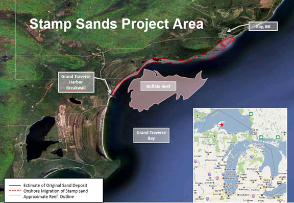
"Buffalo Reef is a 2,200-acre spawning reef located down drift of stamp sands that have eroded into Lake Superior since the early 1900s," said Phil Schneeberger, DNR Fisheries Division Lake Superior Basin coordinator. "It is currently estimated that this reef, critical to both lake trout and lake whitefish populations in the area, is currently 35 percent unusable by spawning fish due to sand that has filled spaces between rocks, which are necessary for successful fish egg deposit and incubation. Furthermore, migrating sands along the shore have made nursery areas unusable by newly-hatched fish."
Charles Kerfoot, Michigan Tech professor in Biological Sciences and director of the Lake Superior Ecosystem Research Center, has worked with the Army Corps and the EPA on the stamp sands project. In 2014 he and several colleagues published an article on the stamp sands that are invading Buffalo Reef. In that article, "Light Detection and Ranging (LiDAR) and Multispectral Scanner (MSS) Studies Examine Coastal Environments Influenced by Mining," published in ISPRS International Journal of Geo-Information, they state the following: "The biological effects of stamp sand encroachment could create several direct and indirect effects. The direct effects are toxic copper impacts on benthic algae, benthic invertebrates and fish. The indirect effects are physical, e.g., stamp sands filling in crevices in boulder fields, reducing the breeding field options and area. With beach seine samples, Bill Mattes (GLIFWC) has documented abundant lake whitefish fry along the white sandy beach, but none along the comparable stamp sand beach stretches. We suggest that whitefish (and all other species) are absent because copper kills benthic organisms (algae and invertebrates) directly, eliminating both invertebrates and their food (algae)."**
Kerfoot told Keweenaw Now he is now working with the Army Corps and DEQ on "long-term modeling and assessing environmental effects of migrating stamp sands in Grand (Big) Traverse Bay (Buffalo Reef, shoreline and rivers, lower bay) and Keweenaw Bay (fisheries)."
Nearly a quarter of the annual lake trout yield from Lake Superior’s Michigan waters comes from within 50 miles of Buffalo Reef. The Great Lakes Indian Fish and Wildlife Commission (GLIFWC) estimates the annual economic benefit of the reef at $1.7 million. Lake trout rely on the spawning habitat of Buffalo Reef, which is threatened with stamp sands that are covering the reef.
"The Keweenaw Bay Indian Community, as well as other tribes located around Lake Superior, are and have always been, fishing tribes," said KBIC President Chris Swartz. "Since time immemorial, these tribes have used the resources provided by gitchi-gami (or Lake Superior) to sustain their communities. This sustenance is not only physical; it is also spiritual, cultural, medicinal and economic."
Swartz said modeling predicts that by 2025, 60 percent of the reef will no longer be viable for lake trout and whitefish spawning.
 In this part of the Keweenaw Peninsula, the coarse, black stamp sands threatening the reef were created as a by-product of century-old copper mining at the Mohawk and Wolverine mines. The mines hauled copper ore from near Calumet 13 miles to a four-stamp mill in the community of Gay, where ore was crushed by the stamps and the copper separated through a flotation process.
Stamp sands were dumped into Lake Superior and on the shoreline. Over the past roughly 80 years, the stamp sands have shifted south -- moved by winds, waves and nearshore lake currents -- about 5 miles to the Grand Traverse Harbor, covering 1,426 acres of shoreline and lake bottom.
Inset photo: A sign posted next to the smokestack and ruins of the stamp sands mill at Gay. (Photo courtesy Michigan DNR)
"Without taking measures to slow the movement and down-drift accumulation of the stamp sands, they will eventually move past the harbor and deposit on the natural white sand beach south of the jetty, at the mouth of the Traverse River," said Steven Check, a project manager with the U.S. Army Corps of Engineers in Detroit.

Officials present dredging project at Public Meeting Aug. 3, 2017
During a public meeting held on Aug. 3, 2017, in Lake Linden, Check explained the need for dredging the stamp sand that threatens the Buffalo Reef spawning habitat, the Grand Traverse Harbor and the shoreline south of the breakwall at the harbor.
The DNR has submitted a joint permit application from the DEQ, under the Natural Resources and Environmental Protection Act, to allow the Army Corps to remove more of the stamp sands from Lake Superior. The permit includes the following statutes:
- Part 301, Inland Lakes and Streams
- Part 325, Great Lakes Submerged Lands
- Floodplain Regulatory Authority found in Part 31, Water Resources Protection
"It's a joint application," Schneeberger explained. "The Corps is preparing the application and they would administer it as far as putting it out to bid and awarding the contract."
Under the permit, a total of 172,500 cubic yards of stamp sands are expected to be removed from an underwater bedrock trough, moving the sand to a 37-acre placement site that has the capacity to store 380,000 cubic yards. This 2,350-foot-long by 700-foot placement area, located about 1.5 miles from the dredge location, would be north of Buffalo Reef, behind a temporary berm.
Another 20,000 cubic yards of sand would be removed from Grand Traverse Harbor, while 10,000 cubic yards of material would be dredged from an upland area next to the harbor, on the beach.

Steve Check described the harbor area and the trough dredging projects included in the permit application during the Aug. 3 meeting (before the DNR's removal this fall of the 9,000 cubic yards from the harbor):
Check explained further the dredging of the trough and the timeline for the project. He also mentioned the permits received by two companies, Torch Lake Industries and Greensand, for removing the sand for commercial purposes.***
Two companies permitted to remove stamp sand
Recently Keweenaw Now learned from Tom Logue, Torch Lake Industries president, that he has received permits from both the DEQ and the Army Corps to remove the stamp sand, load it on a barge or other vessel at the former Coal Dock area, and ship it to Chicago.
"We are actively developing markets and intend to be shipping out sand by spring 2018," Logue said. "Conveyor belts take the sand and deposit it into a vessel. We're using state-of-art machinery so there won't be any dust when the conveyor belt loads the ship."
According to Logue's DEQ permit, "The total amount of dredging associated with excavation/dredging of the dry stamp sand deposit and submerged stamp sands, as well as construction of the Coal Dock mooring facility, is estimated to be 2,155,000 cubic yards, for a 5-year time period."***
Logue added the State Historic Preservation Office approval (for the historic Coal Dock) is included in his Army Corps permit.
Today Dan LeVeque of Greensand told Keweenaw Now he has received the DEQ permit. His Army Corps permit is nearly complete.
"Greensand Inc. has a permit from the State to remove and process the stamp sand," LeVeque confirmed. "The USACE is in process of finalizing their permit but had to wait for a review by the State Historical Preservation Office ( SHPO ). That process is close to complete. Greensand Inc. is working on a number of initiatives for beneficial re-use of the stamp sand which will allow for clean up of the beach and affected lake bottom. The intent is to fund the clean up effort while creating local jobs and improving the local economy."
LeVeque noted Greensand's means of transporting dredged sand is unknown at this time, although Greensand's DEQ permit includes truck transport off site and construction of a stamp sand processing facility.***
Stamp sand removal requires long-term plan
"This dredging project would buy 5 to 7 years of protection for the reef and the whitefish juvenile recruitment area south of the harbor," said Steve Casey, Upper Peninsula district supervisor for the Michigan DEQ's Water Resources Division. "In the meantime, we need to develop a long-term, adaptive management plan, a solution, for the Gay stamp sands problem."
Casey, who moderated the Aug. 3 meeting, fielded questions from the audience following Check's presentation.
Since trucking the 30,000 cubic yards of stamp sand from the harbor area to the projected placement area -- about four miles on the beach -- was mentioned as a likely means of moving that sand, local residents expressed concerns about impacts of the truck transport during the four-month period of the project in 2018. Casey and Check commented on how impacts might be kept to a minimum:

During the Aug. 3 meeting, Michigan Tech Professor Kerfoot mentioned the importance of dredging stamp sand in the harbor to prevent potential flooding of the Traverse River. Other questions from the audience included concerns about the total amount of stamp sand and the capacity of the placement area:
Following the Aug. 3 meeting, local Big Traverse resident Brian Hesterberg, a descendant of the Erkkila fishing family, commented positively on the project presentation.
"I think the project is a well thought-out, short-term solution that receives my approval," Hesterberg said. "I thought the agency speakers explained the project very well."
Michigan State Rep. Scott Dianda spoke briefly at the Aug. 3 meeting. He told residents efforts would be made to water the dust from trucking the stamp sand and encouraged them to contact him with their concerns. He also expressed his hopes for a long-term solution to the stamp sand removal.
"If there is a value to that sand we want to be able to market that and clean that entire place up," Dianda said.
One concerned resident submits public comment, requests public hearing
A public comment period on this permit closed Nov. 1, but the DEQ reported receiving only one comment -- from John Sewell, a concerned landowner, 24-year Houghton County resident and professional engineer. Sewell requested a public hearing on the project, expressing his concerns about the Buffalo Reef spawning grounds and future plans for actions to follow the dredging covered by the present permit application.
Sewell has studied the documents for this 2018 project but still has questions. He would like to know, he says, what scientific tests will be performed on the dredged stamp sand.
"For every statement or conclusion I would like to see the empirical data that supports those comments," Sewell told Keweenaw Now. "Not all stamp sand mixtures are the same. I haven't seen evidence that all stamp sand mixtures have heavy metals."
EPA funds 2018 project with $3.1 million, forms task force; public meeting to be Dec. 5
The EPA (Environmental Protection Agency) has provided $3.1 million to the Army Corps to design and carry out the four-month dredging work, scheduled to begin in May 2018.
No public hearing for this permit application is planned. However, The EPA has formed a cooperative multi-entity task force to develop a plan over the next couple of years and to solicit input from many stakeholders, including the public.
One critical component of the long-term plan will be to develop a beneficial use for the stamp sands, which is currently being explored by the MTECH SmartZone in Houghton. A primary goal of the plan would be that long-term maintenance would be assumed by a non-federal entity.
A public meeting of the task force to kick off the effort has been scheduled for 6 p.m. - 8 p.m. Tuesday, Dec. 5, 2017, at the Lake Linden-Hubbell High School Auditorium, located at 601 Calumet Street in Lake Linden. A permitting decision deadline is set for Dec. 14, 2017.
"We will be soliciting public input on what issues the plan needs to address and looking for volunteers to help us understand and resolve those issues," Casey said.
According to the DNR, a task force steering committee has been named which includes Lori Ann Sherman, natural resources director for the Keweenaw Bay Indian Community; Tony Friona, Great Lakes liaison for the U.S. Army Corps of Engineers’ Engineer, Research and Development Center; and Steve Casey, U.P. district supervisor of the DEQ’s Water Resources Division.
"We’re hoping construction can start on some type of control mechanism for the original pile of stamp sands by 2021, with completion two years after that," Casey said. "We would then hope to put long-term maintenance dredging in place by 2026. The annual costs for that dredging would depend on which type of long-term remedy is selected."
The stamp sands source pile at Gay was originally estimated to contain 22 million cubic yards of material, with 2.3 million cubic yards of material remaining today.

The community of Gay is named for Joseph E. Gay, who conducted early explorations of the ore body that would be mined by the Mohawk Mining Co.
Meanwhile, a separate dredging project has been proposed by private parties for a stamp sands deposit on the southwest side of the Keweenaw Peninsula. The project would extend roughly 13 miles, from the Village of Freda to the North Portage Entry. This proposal is currently under permit application review by the DEQ Water Resources Division and is in no way associated with EPA Task Force, DNR and Army Corps of Engineers efforts at the Gay stamp sand deposit. A public hearing is planned for spring 2018. No date for that session has been determined.
Editor's Notes:
* To access the permit application and other documents related to this project, click here and then click on Documents at the top of the page. Choose a document to download. The current permit application is listed as Keweenaw Stamp Sands JPA 19Sep17.pdf. You should be able to download the pdf and/or print it.
** Click here to access this article: Kerfoot, W. Charles, et al. "Light Detection and Ranging (LiDAR) and Multispectral Scanner (MSS) Studies Examine Coastal Environments Influenced by Mining." ISPRS International Journal of Geo-Information. 2014, 3(1), 66-95. See pp. 84-85.
*** Click here for the DEQ permit and related documents for Torch Lake Industries (click on Documents). Click here for the permit and related documents for Greensand from DEQ (click on Documents).


No comments:
Post a Comment