See our right-hand column for announcements and news briefs. Scroll down the right-hand column to access the Archives -- links to articles posted in the main column since 2007. See details about our site, including a way to comment, in the yellow text above the Archives.

Tuesday, July 13, 2021

Menominee River Water Celebration to be July 16 in Marinette, WI

The beautiful Menominee River. (Photo courtesy Coalition to SAVE the Menominee River, Inc.)

The public is invited to a FREE event, open to all, to protect water and sacred sites from the threat posed by the Back Forty Mine project.

Join water protectors, beginning at Noon on Friday, July 16, at Stephenson Island, 1680 Bridge St., Marinette, WI, to celebrate and bless the Menominee River -- with participation by the Menominee Indian Tribe of Wisconsin, the Indigenous Caucus of the Western Mining Action Network, and the Coalition to SAVE the Menominee River, Inc.

A special ceremony will be held by members of the Menominee Nation to bless the waters of the Menominee River, which is their namesake River and the location of many sites sacred to the Tribe.

The celebration continues with updates on the mining threat facing the Menominee River, including a keynote speaker and longtime environmental advocate  -- Dr. Al Gedicks of the Wisconsin Resources Protection Council.

MUSIC -- Larry Mullins and band will present river songs and showcase the three custom-built guitars to be raffled off at 3:30 p.m. Entitled the "River’s Edge Trio," these guitars were handcrafted by Warren McKenney and appraised at $4,500. The winning ticket will receive all three guitars!  Proceeds from ticket sales go to support the mission of the Coalition to SAVE the Menominee River, Inc.

FOOD -- Dorothy’s Haven of Hope will provide food at the event. Hamburgers, cheeseburgers, brats, hot dogs, chips, soda and water will be available for sale, as a fundraiser for Haven of Hope. The first 100 people in attendance will receive a coupon for a FREE hot dog! Please go to the Coalition booth next to the stage for your coupon.

The event will conclude with a Bridge Walk -- mine protestors walking with signs to show opposition to plans that could endanger sacred sites and the health of both the River and residents or visitors to the area.

Mark your calendar for July 16 -- supporters of the Menominee River would love to see you there!

Stephenson Island is located in the Menominee River within the boundary of Marinette, Wisconsin, at a latitude of 45.1019294 north and longitude 87.6292735 west, at an elevation of 587 feet. It is named after Isaac Stephenson, a prominent politician and lumberman in Marinette at the turn of the 20th century. The island is operated as a city park and is uninhabited. US Highway 41 runs across it, providing access to the park's pavilion, gazebo, playground, and picnic areas. A footbridge to the island connects from the Marinette side of the river, adjacent to the Wisconsin Tourist Information building and the Stephenson Public Library. The island is a popular place for access to the Menominee River for sport fishing and launching recreational boats. The island's facilities host Marinette's "Sunset Concert Series" for Marinette's concerts. (Other concerts in the series are hosted by Marinette's twin city, Menominee, Michigan.)

Editor's Note: Water protectors spent July 1-4 celebrating the river with their 3rd Annual 4-Day Menominee Canoe Trip. Watch for photos and videos, coming soon!

Friday, July 09, 2021

Guest article: Enbridge holding the Great Lakes hostage

By Barbara With*
Illustration by William J Krupinski.

Posted July 8, 2021, on Wisconsin Citizens Media Cooperative.
Text and images reprinted with permission.

Enbridge is holding the Great Lakes hostage. The Canadian foreign multi-national oil company is being enabled and protected by the State of Minnesota to take 5 billion gallons of our water as they rip their Line 3 across our forests and rivers, basically saying F-you to us and our kids and grandkids, to the health and well-being of the planet, and life as we know it. 

Red Lake Treaty Camp. (Photo © and courtesy Barbara With)

On Nov. 16, 2020, 12 out of the 17 members of the Minnesota PCA’s Environmental Justice Advisory Group (MPCA) announced their resignation in protest of the decision to allow Line 3 to move forward. Their resignation letter criticized the pipeline’s environmental risks and the route’s violation of Indigenous treaty rights.

"The decision to approve the permit sends a clear message that the Walz Administration and the MPCA hold no regard for the well-being of Minnesotans or our relatives around the world, who depend on us to dramatically, rapidly, and justly transition our economies away from fossil fuels," the letter reads.

Water protectors during Treaty People Gathering in Minnesota June 2021. (Photo © Unicorn Riot and courtesy Barbara With)

"In this territory alone, over 800 wetlands, 200 water bodies, 22 rivers -- that’s what Enbridge seeks to contaminate with its tar sands," Tara Houska, lawyer and founder of the Giniw Collective, told Democracy Now!’s Amy Goodman. Houska noted that Enbridge bills Line 3 as a "replacement" project, but that is not the case. "It’s a brand-new pipeline and a brand-new route," she told Goodman. "They want a new corridor. There is no pipeline in the places that we’re talking about. There is nothing there. It’s just pristine ecosystems." 

Shell City Campground Water Protector camp, July 2021. (Photo © Rebecca Kemble and courtesy Barbara With)

Enbridge marches on, despite the cataclysmic danger. Despite violating treaty rights. Despite the public outcry. Despite warnings that the impact of Line 3 tar sands will be like building 50 coal plants. Despite the damage they will do to millions of lives. Despite lawsuits from the Bad River Band of Lake Superior Chippewa, who are suing to get Enbridge to take their 67-year-old Line 5 pipeline out of the Penokee watershed in northern Wisconsin. Despite the ailing pipes of Line 5 that cross under the Straits of Mackinac, on the way to Canada again to be shipped to foreign markets, currently operating illegally.

Water protectors evicting Enbridge from the Straits of Mackinac, May 13, 2020. (Photo © and courtesy Barbara With)

Enbridge is holding the planet hostage, purposefully sending us into extinction… for what? It’s not like we don’t have what we need to make the transition into a new sustainable world without fossil fuels.

Water protectors at Minnesota Governor’s mansion. (Photo © Kori Suzuki, 2021, and courtesy Barbara With)

Then there’s all those Democrats who have been claiming to care about the impending climate chaos. Why then is Gov. Walz in bed with Enbridge? As is the Fond du Lac Tribal Council, despite the 7th Fire Prophesy. Why does President Biden side with Enbridge? But even in Michigan, an order from Governor Whitmer terminating Enbridge’s permit to operate isn’t stopping the oil cartel from now operating illegally and dangerously under the Straits of Mackinac.

We are all water protectors now. Take action to help stop Line 3 and Line 5. Future generations are depending on us.

Overpass Light Brigade. (Photo courtesy Overpass Light Brigade)

* Guest author Barbara With is a journalist for the Wisconsin Citizens Media Cooperative.

Saturday, July 03, 2021

Environmental, tribal groups comment on decision to have US Army Corps conduct EIS for proposed Line 5 tunnel in Straits

By Michele Bourdieu

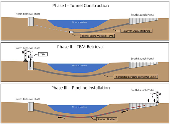
This figure showing proposed three phases of construction for the Enbridge Line 5 tunnel appears on the Feb. 1, 2021, project update from the US Army Corps of Engineers, Detroit District. (Image courtesy US Army Corps of Engineers)

DETROIT --  Environmental and tribal groups have welcomed the June 23, 2021, decision that the US Army Corps of Engineers (USACE) will conduct an Environmental Impact Statement (EIS) for Enbridge’s proposed Line 5 oil tunnel through the Straits of Mackinac, but these groups have expressed some continued concerns that the EIS include a thorough review and respect treaty rights.

A June 23 article from the US Army cites Acting Assistant Secretary of the Army for Civil Works as saying, "'USACE will ensure all potential impacts and reasonable alternatives associated with this project are thoroughly analyzed and will ultimately support a decision on the permit application. The USACE received thousands of public comments and tribal input on the proposed project, which warrant further review through an EIS, including potential impacts to navigation.'"*

Oil and Water Don't Mix (OWDM) -- a coalition of community groups, organizations and businesses concerned with the threat of Enbridge's Line 5 through the Straits of Mackinac -- calls the June 23 decision a major development. The coalition states that a project of this magnitude requires a full review under the National Environmental Protection Act (NEPA), something Enbridge has resisted. 

"Serious concerns about this massive project in the heart of the Great Lakes have been raised by engineers and other scientists," said Sean McBrearty, OWDM Coordinator.

OWDM notes the following on their Web site:

"Annual greenhouse gas emissions attributable to the oil and natural gas liquids transported by Line 5 are in the millions of metric tons and would contribute to greenhouse gas emissions for the next century if Enbridge’s plans are approved.

"The Army Corps should also take a hard look at the impacts of the Line 3 and Dakota Access pipelines, which also threaten clean water, Indigenous rights, and the climate. Boring an unprecedented tunnel through the bedrock and soils of the Great Lakes threatens to violate a host of federal, state, or local laws or requirements imposed for the protection of the environment. It is difficult to imagine how Enbridge’s tunnel project can survive the kind of thorough, independent evaluation that is now possible with this recent Army Corps decision."

Jeffrey Towner of Negaunee Township, who is a retired Corps of Engineers regulatory program supervisor, told Keweenaw Now he believes the Army Corps is making the right decision in requiring an EIS for the tunnel project. He also expressed hope for more public input.

"An EIS provides a much more detailed analysis and public interest review than the more cursory environmental assessment process," Towner said. "In order to issue a permit, among other things, the Corps must find that the project construction and operation will not be contrary to the public interest. In addition to the comment period allowing written comments, I would certainly hope that the Corps will hold several public hearings, including in communities adjacent to the Straits of Mackinac, to accept comments from agencies, non-governmental organizations, Tribes, and individual citizens."

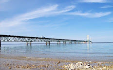
This map shows the location of the existing Line 5 dual pipelines -- dotted lines to the west of the Mackinac Bridge (at right, in red) between St. Ignace and Mackinaw City, Michigan. Enbridge hopes to replace the 67-year-old Line 5 with a pipeline inside a tunnel under the lakebed of the Straits. (Image courtesy US Army Corps of Engineers)

FLOW (For the Love of Water), a Great Lakes law and policy center in Traverse City, Michigan, protecting the magnificent, shared waters of the Great Lakes Basin through public trust solutions, posted this on their Facebook page:

"This is big news! The Army for Civil Works, which oversees the U.S. Army Corps of Engineers, announced Wednesday (June 23) that it would require the corps to develop an environmental impact statement regarding the Enbridge permit application for a Line 5 oil tunnel in the Straits of Mackinac because of 'the potential impacts significantly affecting the quality of the human environment.'

"FLOW's legal team aided in this effort by submitting comprehensive comments to the U.S. Army Corps of Engineers calling for an environmental impact statement on behalf of a dozen organizations: Chippewa Ottawa Resource Authority (CORA), Clean Water Action - Michigan, FLOW for Water, Groundwork Center, League of Women Voters of Michigan, Michigan Environmental Council, Michigan League of Conservation Voters, NMEAC, Sierra Club Michigan Chapter, Straits Area Concerned Citizens for Peace, Justice and Environment, Straits of Mackinac Alliance, and TC 350."**

The Chippewa Ottawa Resource Authority (CORA) -- a coalition of five 1836 Treaty fishing tribes in Michigan -- Bay Mills Indian Community, Grand Traverse Band of Ottawa and Chippewa Indians, Little River Band of Ottawa Indians, Little Traverse Bay Bands of Odawa Indians, and Sault Ste. Marie Tribe of Chippewa Indians -- issued in 2017 a "Resolution in Opposition to Placing an  Oil Pipeline in Trenches or Tunnel Beneath the Straits of Mackinac," stating, in part, that "both trenching and tunneling beneath the Straits of Mackinac will have significant adverse effects to the Treaty Fishery in that area including significant disruptive effects on the bottomlands, water quality, fish spawning shoals and will require disruption of tribal commercial and subsistence fisheries" and "construction of new pipelines in the Straits of Mackinac, be they in trenches or tunnels, will not eliminate the risks of an oil spill in the 1836 Treaty ceded lands and waters." CORA is also a member of the Oil and Water Don't Mix coalition.

Beverly Carrick, CORA’s Interim Executive Director, stated CORA's reaction to the decision for an Army Corps EIS:
"CORA has been urging the Army Corps to conduct an EIS on Line 5 for many years now and we are pleased to see that they are finally going to follow through. CORA will be carefully following the EIS development to ensure that tribal treaty rights are protected. We believe that the best alternative to a tunnel and continued operation of Line 5 is to simply shut it down and decommission it."

This image showing wetland impacts of the proposed tunnel project is one of several diagrams included in the US Army Corps of Engineers Public Notice on Enbridge's tunnel application. Click here for a larger version of this diagram on p. 12 of the Army Corps Public Notice of May 15, 2020.

The Bay Mills Indian Community, a CORA member, has also opposed Line 5 and the tunnel consistently and is in litigation against Enbridge.

Whitney Gravelle, Bay Mills Executive Council chairwoman, told Keweenaw Now the decision for the Army Corps to require an EIS has great significance because of treaty rights.

"The decision by the Army Corps of Engineers to require an Environmental Impact Statement for the proposed Enbridge Line 5 pipeline carries enormous significance because it will require an in-depth analysis of the pipeline tunnel's environmental impacts," Gravelle said. "Tribal Nations are encouraged to see that the Army Corps of Engineers heeded our call to undertake a more rigorous analysis of these environmental impacts, because that also requires a more rigorous analysis of how the tunnel project will impact our treaty-protected interests in the Straits of Mackinac. As part of this EIS process, the Corps will need to honor its treaty obligations to Bay Mills and other Tribal Nations, including considering the impact of the tunnel project on tribal resources."

Concerning Bay Mills' involvement in litigation, Gravelle, noted the following: "Yes, we are an intervening party before the Michigan Public Service Commission and have filed a contested case petition against the Environment Great Lakes and Energy Department (EGLE) as well for issuance of the permits in January 2021. We have also filed an amicus brief in Governor Whitmer v. Enbridge, et. al and are actively involved in tribal consultation with several state and federal agencies."***

Lisa Patrell, spokesperson for the Michigan Anishinaabek Caucus, said the Army Corps EIS must include Treaty Rights, a prehistoric site, and endangered and threatened species.

"This (decision) satisfies one of the demands of many Tribal citizens and water advocates," Patrell stated. "Unfortunately, there is no guarantee that a completed EIS will result in the denial of the permit, but it is a delay. The delay could be several years."

Patrell pointed out that the Corps' own general definition of what areas an EIS should address leaves out facts and specifics, such as Treaty Rights.

The Corps states the following on what an EIS should consider:

"Although requirements differ between situations, an EIS must address the total impact on the environment and consider numerous factors. Examples of factors considered are:

  • the environmental impact of the proposed action
  • any adverse environmental effects which cannot be avoided should the proposal be implemented
  • alternatives to the proposed action
  • the relationship between local short-term uses of man's environment and the maintenance and enhancement of long-term productivity, and any irreversible and irretrievable commitments of resources which would be involved in the proposed action should it be implemented."****

Patrell added, "Neither are endangered or threatened species explicitly mentioned, although the first and second bullet point could be construed to include them. Endangered and threatened species are the purview of the U.S. Department of Fish and Wildlife."

While Treaty Rights guarantee the right of Tribal citizens to hunt, fish and gather in the Great Lakes ecosystem, an additional concern is the September 2020 discovery of a submerged prehistoric indigenous site under the Straits just west of Line 5.

Potential cultural site observed with side-scan sonar in late summer 2020. Note circle of stones that may have been placed in this arrangement about 10,000 years ago, near the end of the Ice Age, when the area would have been above water. (File photo courtesy Terri Wilkerson)*****

"The Corps’ EIS generic scope does not include prehistoric, historic, or cultural sites," Patrell said. "The Michigan Anishinaabek Caucus recognizes that the Corps customizes an EIS scope for every study. Thus, the Michigan Anishinaabek Caucus requests that the Corps explicitly include Treaty Rights, endangered and threatened flora and fauna, and the submerged indigenous prehistoric site in the EIS scope."

NOTES:

* See: "Acting Army assistant secretary announces USACE will conduct an EIS for Enbridge Line 5."

** You can read those joint comments here:

Dec. 15, 2020 -- Supplemental Comments to USACE permitting on proposed tunnel

July 14, 2020 -- Comments to USACE permitting on proposed tunnel

*** See our Feb. 9, 2021, article, "EGLE approves some permits for Enbridge tunnel project; tribal, environmental groups challenge EGLE decision."

**** See USACE's "What is an Environmental Impact Statement?"

***** See our Oct. 17, 2020, article by Terri Wilkerson, "Ancient underwater tribal cultural site discovered in Mackinac Straits near Line 5."

See also the Detroit Free Press article, "Group thinks it has found proof of 10,000-year-old, Ice Age culture in Straits of Mackinac."

Friday, July 02, 2021

Houghton Waterfront Beach reopens; Portage Canal advisory lifted

HOUGHTON COUNTY -- The Western Upper Peninsula Health Department (WUPHD) -- working in conjunction with the Environmental Protection Agency (EPA), the Michigan Department of Environment, Great Lakes, and Energy (EGLE), and the Department of Health and Human Services (MDHHS) -- has lifted the public health advisory for the Portage Canal following the recent fuel spill in Houghton County.

The City of Houghton waterfront including the Kestner Waterfront Park Beach area has been reopened for swimming and other water recreation. Fuel sheen in this area has dissipated; surface water samples collected at the beach have determined that the water is safe for swimming; and the sand at the beach has been removed and replaced.

Recent aerial drone footage has observed no widespread fuel sheen on the Portage Canal; therefore, the public advisory has been lifted. There may be isolated pockets of sheen along the shoreline of the canal. The public should avoid all contact with the sheen. Direct exposure of the eyes, skin, and respiratory tract to fuel sheen can cause tissue injury and irritation; therefore, the public should wash skin with soap and water after contact. All areas on the Portage Canal are now open to body contact swimming as long as no visible fuel sheen is present.

According to BeachGuard, all beaches in the Upper Peninsula of Michigan are open going into the 4th of July weekend. Beach closures and swimming advisories for the entire state can be viewed on BeachGuard at www.egle.state.mi.us/beach.

Thursday, July 01, 2021

UPEC Livestream to present Canadian pipeline researcher on Enbridge and Line 5 TONIGHT, Thursday, July 1

The Upper Peninsula Environmental Coalition’s Livestream Series will present "A Canadian Speaks Out on Enbridge and Line 5," with Gerald Kruk, pipeline researcher, at 8 p.m. EDT TONIGHT, Thursday, July 1, via Facebook and Zoom (links below).

Canada and Enbridge have been waging a major campaign in the US to keep Line 5 from being shut down. Hear from a Canadian who says his country and the company have hurt themselves with their virulent rhetoric and negative behavior!

UPEC'S speaker, Gerald Kruk, is a resident of Calgary, Alberta, home of Enbridge, the owner of Line 5. In a recent editorial, Mr. Kruk, who is a professional in the petroleum industry, brought to the fore the basic problem with Enbridge: lack of trust and loss of reputation. The rapid expansion of pipelines during the last dozen years led to localized opposition, later joined by national-scale climate-change activists. In the case of Enbridge, it was the pipeline rupture on the Kalamazoo River in 2010 that fully exposed its complacency about safety.

Gerald Kruk worked as a corporate manager and independent consultant in Canada’s petroleum and pipeline industries from 1974 to 2015. He is now a researcher and writer on pipeline issues.

Join the livestream on Facebook at https://www.facebook.com/195291337192049/live/

or on Zoom:

https://us02web.zoom.us/j/83113438020?pwd=d3pZcjNyYW9uVmZUTy9vc2ZIN0UwUT09

Meeting ID: 831 1343 8020

Passcode: 2021

Saturday, June 26, 2021

US-41 now open to traffic following fuel spill remediation; WUPHD updates health advisory for Portage Canal areas

US-41 at Santori's Corner in Hancock is now open to traffic following remediation of the fuel spill from a tanker that tipped over here on Thursday, June 24. (Photo courtesy City of Hancock and Copper Country Strong Facebook pages)

HANCOCK -- The Houghton County Office of Emergency Measures reported today, Saturday, June 26, that Highway 41 in Hancock is now open to all traffic. Drivers should be cautious of construction and work vehicles in the area where the spill occurred. Ethel Avenue remains closed at the end near US-41 while crews continue to flush the storm sewer.

White Street has returned to one-way traffic going uphill from downtown Hancock to US-41. 

In response to the gasoline spill there has been absorbent boom material around the outlet of the storm sewer line into the Portage Canal. Petroleum from within that boom area has been, and continues to be, safely removed for proper disposal.

The gasoline sheen on the water has been monitored from the shoreline, from air via drone and plane, and from water via boat since noon on Thursday. Air monitoring has been conducted along the shorelines of the canal. The ongoing monitoring of the sheen -- size and location -- has shown that the sheen has been naturally dissipating, especially east of the Portage Lake Lift Bridge.

This photo, upper left, shows the approximate location of the boom at the outfall into the canal and delineation of the sheen moving toward the Portage Lift Bridge on Thursday. (Drone image courtesy Superior Search and Rescue)

The recommendation of both the Environmental Protection Agency (EPA) and Michigan Department of Environment, Great Lakes and Energy (EGLE) is to continue to monitor the gasoline sheen as the sunlight continues to aid in its evaporation. That is expected to continue into next week, depending on the weather. Mechanical methods of surface recovery used with heavier oils are not effective with the gasoline sheen. Chemical methods of removing the gasoline are not allowed on the Great Lakes.

The EPA has been overseeing and conducting air monitoring in the community. All levels in the community are safe. The only areas where gasoline compounds continue to be found are the storm drains and work areas.

Health Department updates advisory

The Western Upper Peninsula Health Department (WUPHD), working in conjunction with the EPA, EGLE, and Michigan Department of Health and Human Services (MDHHS), has updated the public health advisory for the Portage Canal following the recent fuel spill in Hancock. The Portage Canal may reopen for recreational boating, fishing, and body contact swimming as long as the public avoids any areas with visible fuel sheen.

Sheen can be described as a rainbow-like discoloration on the surface of the water. Sheen location may quickly change along with shifts in wind and weather.

Recreational use is not recommended for the following areas due to the current visible presence of fuel sheen (as of Friday, June 25):

Hancock Waterfront -- Between the release site (below the Jutila Center) east to Mill Street and from the lift bridge east to the National Historical Park smelter site.

Houghton Waterfront -- Directly across from the release site (below the Jutila Center) extending all the way east to Lake Street (near Super 8). This includes the Kestner Waterfront Park Beach area.

WUPHD advises that direct exposure of the eyes, skin, and respiratory tract to fuel sheen can cause tissue injury and irritation; therefore, the public, including pets, should avoid swimming and recreation in these areas. All other areas on the Portage Canal may reopen to body contact as long as no visible fuel sheen is present. Updates will be issued as additional information becomes available.

Friday, June 25, 2021

Hancock Fire Department: Fuel spill cleanup ongoing; US-41 may reopen Saturday, June 26

This drone photo of the fuel spill remediation scene at Santori's Corner is from Thursday night, June 24. (Photo courtesy Superior Search and Rescue via City of Hancock Facebook page)

HANCOCK --  The Hancock Fire Department today, Friday, June 25, sent this update on the cleanup of the fuel spill that occurred on Thursday at Santori's Corner in Hancock:

Highway 41 at the scene of the spill is being remediated and replaced today. It is still hoped the road will reopen Saturday. Access to The Tire Shop has been restored. Customers can access it through North Ethel Avenue.

Drinking water has been and continues to be safe.

Detours remain in place. As a reminder, through traffic is requested to use alternative routes, with northbound traffic asked to follow M-203 toward McLain State Park and southbound traffic asked to take Airport Park Road through Dollar Bay. This is especially true for tractor trailers. Local traffic is open, and White Street in Hancock is currently open to two-way traffic because of the incident.

Beaches along the Portage Lake Shipping Canal remain closed until further notice.

Due to the petroleum release and the heavy equipment operating in the area, residents are requested to avoid the area if possible

The next update will likely come when the road is opened.

Editor's Note: 

For previous updates see our June 24 articles:

UPDATE: Hancock Fire Department offers update on June 24 fuel spill on US-41

and Health Department issues Public Health Advisory, Precautionary Canal and Beach Closure due to fuel spill discharge into Portage Canal.

Thursday, June 24, 2021

UPDATE: Hancock Fire Department offers update on June 24 fuel spill on US-41

This map shows the areas in Hancock that were evacuated today, June 24, because of the fuel spill caused by a gasoline tanker that tipped over near Santori's Corner on US-41 this morning. (Map courtesy Hancock Fire Department)

UPDATE: 9:46 p.m. Thursday, June 24: The Hancock Fire Department is lifting the evacuation order that was in place. Residents are encouraged to return home. The Western U.P. Health Department, with assistance from the Hancock Fire Department, provided printed guidance to residents who will be reoccupying their homes. Air monitoring will continue to take place over the coming days.

Beaches along the canal will remain closed until further notice.

Highway 41 will remain closed overnight into the morning. It is likely the highway will not be open for traffic until Saturday. Detours will remain in place through at least tomorrow morning. See Traffic Detours below.

Due to the petroleum release and the heavy equipment operating in the area, residents are still requested to avoid the area if possible.

The next briefing will come out tomorrow when more information is known.

The following article was posted earlier today:

HANCOCK -- The Hancock Fire Department, through the City of Hancock, has sent the following update on today's fuel spill, marked in blue on the map above.

Around 8 a.m. today, Thursday, June 24, a gasoline tanker tipped over at Santori’s Corner on US Highway 41 in west Hancock. The tanker immediately started spilling gasoline. It was carrying about 8,500 gallons. Currently, it is unknown how much spilled. There have been no injuries caused by the accident and spill. Drinking water has not been affected.

The spilled fuel can be seen here moving east along the Portage Canal toward the Portage Lift Bridge. (Photo courtesy Superior Search and Rescue) 

The Western Upper Peninsula Health Department (WUPHD), working in conjunction with the Environmental Protection Agency (EPA) and the Department of Environment, Great Lakes, and Energy (EGLE), issued a public health advisory for the Portage Canal and beaches near Houghton/Hancock due to the fuel spill that discharged into the Portage Canal in Houghton County.

Evacuations are in place in west Hancock from Santori’s Corner on South Lincoln Drive (Highway 41) to Michigan Street, Michigan Street up to Elm Street and down to the Jutila Center, and Minnesota and Ohio Streets between Ethel Avenue and Michigan Street. See above map. It is currently unknown when residents will be allowed to return to their homes. An update on that will be given later tonight if possible.

Traffic Detours: Through traffic is requested to use alternative routes, with northbound traffic asked to follow M-203 toward McLain State Park and southbound traffic asked to take Airport Park Road through Dollar Bay. This is especially true for tractor trailers. Local traffic is open, and White Street in Hancock is currently open to two-way traffic because of the incident. Traffic is not expected to return to normal until late tonight, at the soonest. There is a potential it will be closed overnight, possibly affecting the morning commute. [See traffic update above.]

The Environmental Protection Agency (EPA), the Department of Environment, Great Lakes, and Energy (EGLE), and Region 8 Hazmat Team is on scene to advise on cleanup efforts. Various contractors are on site and on route for cleanup efforts.

Cleanup efforts at Santori's Corner on US-41 require the highway to be closed to through traffic. (Photo courtesy Superior Search and Rescue)

Due to the petroleum release and the heavy equipment operating in the area, residents are requested to avoid the area if possible.  

Updates as the day goes on and photos and videos from the scene will be posted to the City of Hancock Facebook page or can be found here.

Health Department issues Public Health Advisory, Precautionary Canal and Beach Closure due to fuel spill discharge into Portage Canal

HANCOCK -- The Western Upper Peninsula Health Department (WUPHD), working in conjunction with the Environmental Protection Agency (EPA) and the Department of Environment, Great Lakes, and Energy (EGLE), is issuing a Public Health Advisory for the Portage Canal near Houghton/Hancock due to a fuel spill that discharged to Portage Canal this morning, June 24, in Hancock.

A fuel tanker truck overturned on U.S. Hwy-41, Santori’s Corner, in Hancock and released gasoline fuel to the ground surface. Fuel discharged to a storm drain that outlets to the Portage Canal. The entire Portage Canal, including public access beaches and boat launches are temporarily closed for recreational boating and body contact.

The primary concern for public safety is exposure to benzene due to inhalation and skin contact. Affected residents near the spill site are being temporarily evacuated by emergency personnel due to safety concerns. The public is encouraged to avoid the affected area at the spill site and to avoid the Portage Canal for any recreational use of the water such as boating or swimming. People and pets should avoid direct body contact and avoid swallowing lake water in this vicinity, especially if fuel is visible on the water surface. Do not use surface water for any drinking water purposes. If you smell fuel, move away from the area.

This is an ongoing emergency situation. Updates will be issued as additional information becomes available.

Editor's Note:

See the on site coverage on Facebook Live by TV6′s Jesse Wiederhold.

Also, according to TV6 News online, "Homes are being evacuated from Ohio and Michigan Streets up to Summit Street and along Ethel Ave. to Ingot Street. Those needing shelter can meet at the Church of Resurrection."

TV6 also reports that, while US-41 is closed, northbound traffic in the area is being re-routed to M-203 and southbound traffic to Airport Park Road and then M-26.

Monday, June 21, 2021

City of Houghton Planning Commission to hold Public Hearing June 22 on new rezoning along Canal Rd.

By Michele Bourdieu

This map shows the area between Canal Road and the Portage Canal, most of which was re-zoned from R-1 to B-2 in February. A recent proposal by a potential buyer would include rezoning Parcels B and C to Reserve zoning for a campground and walking trail along the Canal; construction of vacation housing units in Parcel D (to remain in B-2); and a boardwalk for visitors in Parcel A (zoned R-1), through the wetland and at the mouth of Cole's Creek. The City of Houghton Planning Commission will hold a Public Hearing on the new rezoning proposal June 22. Click on map for larger version. (Map courtesy City of Houghton)

HOUGHTON -- The City of Houghton Planning Commission will hold a Public Hearing at 5:30 p.m. (EDT) Tuesday, June 22, in the City of Houghton Council Chambers, 616 Shelden Avenue, Houghton, on a proposed rezoning of part of the area between Canal Road and the Portage Waterway (Portage Canal) known as the Cole's Creek Sands -- which was rezoned recently to B-2 with conditions (commercial) to allow a wide range of development. Two parcels in that area (B and C in the map above) are now being considered for a change to the more restrictive "Reserve" (RSV) zoning because of a potential buyer's concept of a planned development. The Public Hearing will also be via Zoom (see below for access).*

The plan would include a campground and vacation housing units. In addition, the proposal includes the wetland area, including part of Cole's Creek, which would remain in R-1 residential zoning, to be used as a nature park with public access and a boardwalk for public viewing. This new development concept is proposed to have less impact on the Superfund cover, part of the Torch Lake Superfund, that still protects the greater part of this area from hazardous industrial waste, including slag -- mining waste from the former Michigan Smelter. That Superfund area was covered with only 6 inches of soil and vegetation. The parcels are presently owned by JRG Enterprises, Inc., who requested this new rezoning.

Derek Bradway, a Michigan Tech graduate in environmental engineering, presented his concept of the planned development in a narrative dated April 30, 2021. In that narrative, he describes the vacation housing as follows: "Proposed development of 18 - 24 timber framed vacation houses. The houses will feature vaulted ceilings and water-facing decks. The typical house will be 2 bedrooms; 1,200 square feet. These timber framed gems will sit atop the upper level of the south end of the land, along Canal Road, facing Portage Canal."

These vacation housing units would be built on proposed Parcel D, which would remain in B-2 zoning.

Chris Woodry, a local homebuilder whose property is located in both the City of Houghton and Adams Township near Cole's Creek, opposed the original rezoning of most of the area to B-2 because of the potential environmental impacts of excavating a Superfund site for large-scale commercial construction.

"I'd still like to see an environmental study done regardless of what happens there," Woodry said, concerning the new rezoning proposal.

As a builder, he questions the developer's being able to fit everything claimed in that space, Parcel D, which is estimated at 5.56 acres.

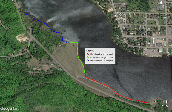
This map shows the locations and relative shoreline lengths for Parcel A (wetland, blue line), which remains zoned R-1; Parcels B and C (green line), proposed for rezoning from B-2 to Reserve (RSV); and Parcel D (red line), which is to remain zoned B-2. Across the Canal, Hancock's shoreline shows Hancock Beach across from the wetland as well as residential and some business properties across from the other parcels. Click on map for larger version. (Map © Google Earth and courtesy Liz Gerson)

Liz Gerson, a concerned Houghton resident, offers an analysis of what the proposed rezoning and potential development would mean to her, illustrated by the Google map above: "The proposed zoning change to Reserve (RSV) involves about 11 acres (of 34 total acres for Parcels A-D), and relatively short stretches of Portage Canal road frontage and shoreline [green line on map]. Zoning for about 1/3 mile of shoreline remains in B-2 with conditions allowing for hotel, unrestricted in height [red line on map]. Directly across the Portage is primarily single family residential property in Hancock. It sounds like the prospective developer would fill this space with 18-24 two-bedroom vacation houses, which would maintain building heights comparable to R-1. If the developer's concept is realized, the daily occupancy level for the entire space will more than double what it would have been if built out at R-1.  Otherwise, the plan seems fairly benign, and I personally have no objection to the partial zoning change to RSV, but will await further information from the public hearing."

The map below includes the approximate number of acres and the shoreline and road frontage lengths for each parcel.

Click here for the June 22 Planning Commission meeting packet, p. 9, and view a larger version of this map. (Map courtesy City of Houghton)

Parcel D would remain in B-2 zoning, Bradway told Keweenaw Now, because it includes R-3, which permits multi-family residential.

Proposed Parcels B and C (about 10 acres) on these maps would be rezoned to Reserve for a campground that could include RVs as well as tents and would include a walking path.

Bradway describes this plan in his concept narrative: "Proposed development of an RV / tent campground. Planned are 46 modern, full hook-up RV sites and 23 Tent sites. Amenities include a 50' x 50' water's edge pavilion, docks for watercraft and fishing, a boat launch, and a playground. The campground will be nestled on the open, flat land. Campground construction is low-impact and minimally intrusive, thereby keeping the remediated site clean and stable. Approximately 350 trees will be planted. Green is good."

This photo shows the NW end of Parcel B, from the Fodermaiers' driveway along Canal Road toward Houghton. It is proposed, along with Parcel C, for rezoning to Reserve for the campground, walking path, and planted trees. Click on photo forClic larger version. (Photo © Google Earth and courtesy Liz Gerson)

Bradway continues, "A walk path from the south end of the property to the north end of the campground along the water will be nearly 3/4 of a mile. A very nice, beautiful stroll."

This photo along Canal Road shows a view of Parcel C in the foreground, looking toward the Fodermaier property and the wetland. Click on photo for larger version. (Photo © Google Earth and courtesy Liz Gerson)

Parcel A on the maps is the wetland bordering John and Bonnie Fodermaier's home. It includes the mouth of Cole's Creek and has remained in R-1 zoning.

This photo shows part of the wetland, viewed from the Fodermaiers' property on Portage Canal. (Keweenaw Now file photo)

In his narrative, Bradway says this about the wetland: "A raised boardwalk, 1/3 of a mile in length, with observation outposts will be constructed on the land around the mouth of Cole's Creek. This 13-acre piece of land is to preserve the wetlands while giving access to all, including the public, to its beauty. Think of it as a smaller version of the Nara Nature Park."**

Bradway noted several environmental and local concerns in a recent conversation with Keweenaw Now.

"The boardwalk will meander in a natural, organic fashion through the entire wetland," Bradway said. "The wood we're going to use for the cabins, the boardwalk and things of that nature will be wood that is locally sourced."

He is planning on more than 300 trees to be planted on the property.

"The majority will be evergreen and some deciduous trees as well," he noted. "That gives better stability for that land as well."

The walking path is to be non-motorized.

"That's for pedestrian traffic only -- or bicycles," Bradway explained, noting the DNR motorized trail is on the opposite side of Canal Road for such vehicles.

Asked about parking, Bradway said individual parking spaces would be provided at the campsites and the vacation homes. Public parking for the boardwalk in Parcel A currently exists near the mouth of Cole's Creek.

Houghton resident Bill Deephouse, former Michigan DNR fisheries biologist, told Keweenaw Now the mouth of Cole's Creek, including the parking lot, has been owned by Dave Jukuri (of JRG) for a long time but was always open to anyone who wanted to use it.

"I sure hope that it will remain open to anglers of all stripes," Deephouse said. "Many times I have seen people out at the mouth in Portage Lake casting for salmon in the fall, and others fish there in the spring for steelhead. Smelting in the spring was a tradition here. But the smelt run has been very low in recent years. The creek always had a nice population of brook trout in it but that was before the 2018 flood. I wouldn't hazard a guess what it is like now short of having the DNR do a survey to assess what is still in the creek."

As mentioned above, Bradway said he intends to keep all of Parcel A open to the public. He also told Keweenaw Now that, previous to his agreement with JRG, Parcel A was under contract to a private individual who wanted to build a house on it. Fortunately that "pending sale" did not go through and Bradway was able to include the wetland in his potential purchase.

"We were a breath away from losing access to the entire 15 acres of wetland," Bradway noted. "Now we can continue to offer the creek for public access and enjoyment, as JRG has done in the past."

John and Bonnie Fodermaier, whose house is between Parcels A and B, are supportive of the rezoning proposal for Parcels B and C and Bradway's plan for the wetland adjacent to their residential property.

In a May 14, 2021 letter to the City of Houghton, Fodermaier writes, "The proposed zoning amendment is extremely compatible with the existing property surrounding the proposed site. The use of the land for an RV Park is in concert with the existing R-1 homes in the area. In addition, the Cole’s Creek
Wetlands would become a nature area open to the public with boardwalks and benches. This would preserve the wild bird nesting area and the trout stream in the best possible way."

Fodermaier notes also that he believes Bradway's proposal for the area will not have an adverse effect on property values. He lists benefits of the rezoning to include lower traffic levels than under B-2, lower light and noise pollution, seasonal impact (May to September only), and no large-scale excavation of the Superfund cover or potential exposure of hazardous materials.***

Also in support of the potential project are John and Suzanne Sanregret, who own property at the south end of Parcel D. In a May 24 letter to the Planning Commission, they state their support for the proposed campground and vacation lodging, noting these will be attractive to tourists with the proximity to the waterway as well as Downtown Houghton businesses and entertainment.

The City of Houghton's packet for the June 22 Planning Commission meeting lists Derek Bradway as manager of Gold Metal Rentals LLC in a May 15, 2021, document signed by F. Michelle Halley, the applicant's attorney.

In the Introduction to this document, Halley states, "JRG and Gold Metal Rentals currently have a Purchase Agreement with rezoning the property being a contingency of the sale. The Reserve District is designed for 'lands bordering the Portage Waterway.' Div. 10, § 98-127.

"Principal permitted uses include one-family dwellings, vacation cottages, and private or commercial recreation areas.  Id. at 98-129. The Applicant’s proposed uses align with these allowed uses."

This document also includes discussion of 17 factors that are considered to determine whether the rezoning meets the goals of the City Zoning Ordinance and the Master Plan.

Some examples are Factor #5, which discusses the need for more camping facilities and vacation homes in the City of Houghton and Factor #9 on whether the physical characteristics of the site are appropriate for this proposed zoning amendment.

In answer to Factor #9, Halley writes,"The land is approved for development by both the U.S. Environmental Protection Agency (EPA) and the Michigan Division of Energy, Great Lakes and  (EGLE). The applicable deed restrictions have been accounted for in this use proposal.

"Furthermore, campgrounds are low-impact and essentially non-invasive developments. The plans show 350 trees to be planted, which will enhance and stabilize this beautifully reclaimed land."****

Houghton City Manager Eric Waara presented the rezoning proposal from JRG to the Planning Commission at their May 25, 2021, meeting. According to the minutes of that meeting, Planning Commissioners made the following comments:

Kristine Bradof said she feels this is a good use of the property as it will not require a lot of digging and this is what Reserve is made for.

Jennifer Julien asked if it would create any problems by only rezoning Parcel B and Parcel C of the development and leaving Parcel A as R-1 and Parcel D as business. City Manager Waara said Parcel D can stay zoned as B-2 to fit the cabins. He does not see a problem with the smaller area rezoned to Reserve.  
He said it is OK to only rezone the areas that need to be Reserve so it will not muddy the zoning.

Bill Leder asked if Mr. Bradway will add a deed restriction on Parcel A so that it remains open to the public. Mr. Bradway said he does not want to put a deed restriction on Parcel A. It is his plan to keep it open to the public. 

At that May 25 meeting the Planning Commission voted unanimously to set a public hearing on this proposed Ordinance 2021-321 for Tuesday, June 22, 2021 at 5:30 p.m.
(See below for access to the June 22 meeting via Zoom.)*****

Bruce Woodry, a concerned Copper Country resident who was among the local citizens opposed to the original zoning change to B-2, told Keweenaw Now he had opposed the February rezoning to B-2 that would allow greater development on this Superfund property because of the strong potential for pollution from the construction site that could migrate to both ends of the Portage Canal. He agreed that this proposal for a campground and walking path in Parcels B and C would have less environmental impact. However, he remains concerned about public participation in the City of Houghton's decisions. He believes the City of Houghton officials do not always follow their own guidelines and procedures in approving zoning and do not respond appropriately to FOIA requests.

"They're not following their own rules," Bruce Woodry said.

He added that the Zoom meetings held because of COVID have helped to involve the public and he hopes all the meetings can continue to be on Zoom permanently to improve public participation.******

Attend Public Hearing via Zoom:

Join Zoom Meeting at https://us02web.zoom.us/j/84937327074
Meeting ID: 849 3732 7074
One tap mobile:
+13017158592,,84937327074# US (Washington DC)
+13126266799,,84937327074# US (Chicago)

Dial by your location:
+1 301 715 8592 US (Washington DC)
+1 312 626 6799 US (Chicago)
Meeting ID: 849 3732 7074

Notes:

* Click here for the June 22 Planning Commission Agenda.

** See p. 10 of the Agenda Packet for the June 22 meeting for Derek Bradway's complete narrative on the proposed development.

*** See p. 16 of the June 22 Agenda Packet for the Fodermaiers' full letter.

**** Attorney F. Michelle Halley's document is on pp. 11-14 of the Agenda Packet linked above. 

***** The minutes for the May 25 Planning Commission meeting are on pp. 2-4 of the Agenda Packet linked above.

****** See the Bylaws for the City of Houghton Planning Commission, which include items on public participation. See also the 2019 City of Houghton Public Participation Plan, prepared by WUPPDR (Western Upper Peninsula Planning and Development Region).

Saturday, June 12, 2021

UPDATED: Portage Lake District Library, Hancock Library launch Summer Reading Program

The Portage Lake District Library (PLDL) and the Hancock School Library will launch their 2021 Summer Reading Program with events on June 17 and June 26. (Image courtesy PLDL)

[New Update: The Portage Lake District Library has CANCELLED the Community Paddle event that was re-scheduled for June 24, because of predicted weather. An August paddle event may be scheduled later.]

HOUGHTON -- The Portage Lake District Library (PLDL) and the Hancock School Public Library are thrilled to launch
the 2021 summer reading program, Tails and Tales. The program will see both libraries engage students and residents in summer reading activities all season long.

Each year, libraries across the country host a summer reading program to keep children and families reading throughout the summer and to help prevent what educators call the summer slide. The summer slide is described as the tendency for students to lose reading achievement gains made the year prior if they are not reading over the summer.

Pre-registration for the reading program will open on Thursday, June 17, alongside an outdoor storytime event, Books Of A Feather, hosted by the Hancock School Public Library from 3 p.m. to 6 p.m. at the Hancock Tori and Farmer’s Market on Quincy Green.

PLDL will host a Summer Reading kick-off event from 11 a.m. to 1 p.m. on Saturday, June 26, at the library. At the kick-off event, participants can sign-up for the program and enjoy ice cream, face painting, and other summer reading themed crafts and activities. The Library Book Bike will also be onsite to share further information about the program and the library.

This year the library will once again offer the ability for participants to register online using the Beanstack app. The online registration portal will allow users to track their summer reading progress from a PC, laptop, or other mobile device. There will also be paper registration available for those who do not wish to participate in the online program.

Summer Reading Program participants will receive prizes and incentives as they reach different reading benchmarks throughout the program. Prizes this year include a free book and a $5 voucher to the Downtown Houghton Farmer’s Market.

The 8-week program will also include outdoor events throughout the summer, such as free paddling programs, live music and outdoor storytime programs. The program ends on August 14.

NEW UPDATE: Community Paddle CANCELLED. See above.

On Thursday, June 24, a community paddle is being hosted by the Portage Lake District Library, Keweenaw Land Trust, and Michigan Tech's Outdoor Adventure Program. This date has been changed because of weather predicted for June 17.

Bring your own boat or boats and instruction will be provided. The paddle will depart from the East Houghton Waterfront Park. Youth paddle (ages 12-17) will be from 3:30-5:30 p.m. and an adult only paddle will depart after 5:30 p.m.

Minors must have a parent present at drop-off to sign a liability waiver. Registration is required and can be found HERE.

The Summer Reading Program is free and open to all. Online registration is also available. Visit the PLDL website at www.pldl.org to learn more.

PLDL and the Hancock Library are open for limited, in-person services with regular hours.*

Based on updated guidance and Emergency Order from MiOSHA and MDHHS, PLDL has made the following changes to their pandemic related policies:
-- Patrons who are not fully vaccinated are required to wear a face mask while in the library.
-- Library employees who are not fully vaccinated are required to wear a face mask while in the library.
Click here for details.

* For PLDL regular hours, click here. For Hancock School Library hours, click here.

Thursday, June 03, 2021

KORC hosts inaugural Keweenaw Clean-up

By Nicholas Wilson*

Keweenaw Outdoor Recreation Coalition (KORC) volunteers assemble after their May 22, 2021, Keweenaw clean-up. Click on photos for larger versions. (Photo © and courtesy Nicholas Wilson)

COPPER HARBOR -- On a warm morning in late May, volunteers gathered in Copper Harbor to participate in the first annual Keweenaw Outdoor Recreation Coalition (KORC) Keweenaw Clean-Up. More than 40 volunteers spent the morning and early afternoon of Saturday, May 22, 2021, collecting garbage from State of Michigan forest and park land, roadsides, and other public areas near Copper Harbor.

Despite unseasonably warm weather and the emergence of Keweenaw’s infamous mosquito and black fly hordes, volunteers succeeded in removing an estimated ton -- 2,000 pounds -- of trash. Garbage was collected from locations including the Mandan Road, High Rock Bay Road and beachfront, West Schlatter Lake Road, Manganese Creek Bridge parking lot, and the Clark Mine.

Beginning at 9:30 a.m., Ben Ciavola and Erika Vye greeted volunteers in the parking lot of The Mariner North to distribute trash bags and maps and to guide volunteers to clean-up locations. DNR volunteer waivers/door prize forms were also collected.  Grant Township Supervisor Scott Wendt provided orange township trash bags, and Ace Hardware in Calumet provided a generous supply of heavy-duty garbage bags in several sizes.

This KORC Clean-Up check-in tent was provided by the Copper Harbor Trails Club. (Photo © and courtesy Gina Nicholas)

Prior to the clean-up, KORC Steering Committee Members Gina Nicholas and Don Kauppi scouted the area for trash and marked roadside cleaning locations to better coordinate volunteer efforts. Maps displaying local landmarks and cleaning locations were developed by Keweenaw Community Forest Company (KCFC) with help from Daniel Lizzadro-McPherson at Michigan Tech and printed courtesy of The Print Shop.

This map, developed by Keweenaw Community Forest Company (KCFC), with help from Daniel Lizzadro-McPherson at Michigan Tech, shows the clean-up locations (red dots) from Copper Harbor to High Rock Bay. Click on map for larger version. (Map courtesy Daniel Lizzadro-McPherson) 

Volunteers spread out along the Mandan Road and surrounding areas to bag roadside debris with the goal of removing items that could be spotted from the road. Heavy items including culverts, pipes, and other large metal objects were also extracted. Mark Ahlborn, Rich Probst and Mark Salo brought trucks and trailers to haul heavy trash bags and large items out of the woods. Don Kauppi took responsibility for disposing of the larger metal items, and other volunteers along with Grant Township paid for all trash to be disposed of without using DNR dumpsters. Recyclable cans and bottles were also collected for deposit return. 

Volunteers return with a trailer of culverts, pipes, and other large debris. (Photo © and courtesy Gina Nicholas)

Volunteers meet in the Mariner North parking lot with trailers and bags full of trash removed from nearby roadside locations. (Photo © and courtesy Gina Nicholas)

Participating volunteers represented a variety of Keweenaw communities, businesses, and recreation interests including overlanders, mountain bikers, and kayakers.


KORC volunteers pick up trash along the Mandan Road.
(Photos © and courtesy Gina Nicholas)

The Keweenaw ATV Club also participated in the event, using side-by-side ORVS to collect trash along the High Rock Bay Road.

Members of the Keweenaw ATV club are pictured here with garbage collected along the High Rock Bay Road. (Photo © and courtesy Gina Nicholas)

After the clean-up, volunteers met in the Copper Harbor Community Park for refreshments prepared and provided by Don and Peg Kauppi, owners of The Mariner North. To celebrate successful clean-up, volunteers enjoyed drinks and food including hotdogs and brats grilled by Roger Perreault.

Volunteers also had the opportunity to win door prizes donated by a variety of local businesses. Prizes included a gift certificate for dinner for two at The Mariner North, a one-night stay at the Copper King, hand painted whiskey glasses from Gail English, a framed picture from George Bailey Photography, a T-shirt and hat from the Gas-Lite General Store, and a hat from the Copper Harbor Trails Club.

The Keweenaw Clean-Up is KORC’s latest initiative to assist the State of Michigan and take practical and helpful actions to care for Keweenaw lands and improve outdoor recreation opportunities for all. KORC plans to continue holding similar volunteer clean-up events in the future. More information about KORC and its projects is available on the KORC website.**

Notes:

* Keweenaw Now guest writer Nicholas Wilson is a Keweenaw resident and free-lance journalist. See also his March 7, 2021,  article, "KORC: Community Action for Permanent Public Land."

** Some of the KORC members mentioned in this article were also quoted this week in the June 2, 2021, Bridge Michigan article, "In tiny Copper Harbor, a mountain biking boom causes growing pains."

Monday, May 31, 2021

Hancock Salvation Army coordinates local donations to help Calumet fire victims

By Michele Bourdieu

Hancock Salvation Army Director Pete Mackin, right, is assisted with sorting clothing donations on May 24 at the Salvation Army office in Hancock. Volunteers pictured here with Mackin are Joe Burglio of Hancock, left, and Cart Spicer, Salvation Army Service Extension Field representative from Crystal Falls. (Photos by Keweenaw Now)

HANCOCK -- The Salvation Army in Hancock has received a great number of donations of clothing, water, food, finances and more for those displaced by the May 21 fire in Calumet. According to a Hancock Salvation Army Facebook post last week, the group is working closely with Calumet Village, the Red Cross and many other state and community leaders to coordinate this effort of assistance, relying mostly on volunteers.

"We’re all set on clothing. Toys, toiletries and financial contributions are still being collected," Pete Mackin, Hancock Salvation Army director, said recently.

According to their Web site now, the greatest need is monetary donations.*

A May 28 post on their Facebook page stated, "We had a great meeting with the Calumet residents displaced by the fire. We’re now steering all of your donations toward helping them rebuild and bless their lives. It is so humbling to be entrusted with stewarding your faithful gifts to help those suffering. This truly is God’s Country."

Last Monday, May 24, during Keweenaw Now's visit to the Hancock Salvation Army, Laurel Maki, president of 31 Backpacks, and her daughter, Melissa Maki, 31 Backpacks vice-president, delivered donations that had accumulated at the Americinn of Calumet. The motel had sheltered some of families left homeless by the fire and stored many of the donations, especially food, and had asked the public to take clothing donations to the Hancock Salvation Army.

Melissa Maki, center, vice-president of 31 Backpacks, delivers donations left at the Americinn in Calumet to Hancock Salvation Army Director Pete Mackin on May 24. Pictured in the doorway is Mimi Boley of Chicago, who recently moved to the Copper Country and works as a volunteer receptionist and secretary in the Hancock Salvation Army office. An unidentified donor, far left, drops off a large number of items.

31 Backpacks is a non-profit organization that provides food for at-risk children on weekends and school breaks. According to Laurel Maki, 31 Backpacks president, the group works with all the K-12 public schools in the Copper Country Intermediate School District. They deliver over 1700 meals a week.**  

Laurel Maki, right, and her daughter, Melissa Maki, of 31 Backpacks are pictured here with some of the donations they delivered to the Hancock Salvation Army on May 24 for the families displaced by the May 21 Calumet fire.

Another community organization that is assisting the Calumet families impacted by the fire is Love INC of the Copper Country. According to David A. Whitaker, Love INC executive director, this group has been collecting food, personal care items, household items, furniture, beds, couches, lamps and more for the 43 victims of the fire.

In a May 28 post on the Hancock Salvation Army Facebook page, Whitaker writes, "Love Inc is now collecting these items, but they must be approved and screened and must be by appointment. You are not permitted to just drop items off without permission. If you don’t have these items to donate, you can send a financial gift to 2801 W Sharon Ave, Houghton MI 49931. Write gift to Love Inc of the Copper Country and designate it Fire Victims."***

In his post, Whitaker also praised Mackin for his work, saying, "Team work makes the DREAM work!! Some awesome things are happening in the Copper Country! Peter Mackin is doing an amazing job coordinating efforts across the county."

Notes:

* To donate money for the fire victims through the Hancock Salvation Army, visit their Web site. You can also donate on their Facebook page. See also a TV-6 video report from the Americinn in Calumet recorded on May 22.

** Learn more about 31 Backpacks on their Facebook page or email 31backpacks@gmail.com.

*** Learn about Love INC of the Copper Country on their Web site.