By Michele Bourdieu
This map shows the area between Canal Road and the Portage Canal, most of which was re-zoned from R-1 to B-2 in February. A recent proposal by a potential buyer would include rezoning Parcels B and C to Reserve zoning for a campground and walking trail along the Canal; construction of vacation housing units in Parcel D (to remain in B-2); and a boardwalk for visitors in Parcel A (zoned R-1), through the wetland and at the mouth of Cole's Creek. The City of Houghton Planning Commission will hold a Public Hearing on the new rezoning proposal June 22. Click on map for larger version. (Map courtesy City of Houghton)HOUGHTON -- The City of Houghton Planning Commission will hold a Public Hearing at 5:30 p.m. (EDT) Tuesday, June 22, in the City of Houghton Council Chambers, 616 Shelden Avenue, Houghton, on a proposed rezoning of part of the area between Canal Road and the Portage Waterway (Portage Canal) known as the Cole's Creek Sands -- which was rezoned recently to B-2 with conditions (commercial) to allow a wide range of development. Two parcels in that area (B and C in the map above) are now being considered for a change to the more restrictive "Reserve" (RSV) zoning because of a potential buyer's concept of a planned development. The Public Hearing will also be via Zoom (see below for access).*
The plan would include a campground and vacation housing units. In addition, the proposal includes the wetland area, including part of Cole's Creek, which would remain in R-1 residential zoning, to be used as a nature park with public access and a boardwalk for public viewing. This new development concept is proposed to have less impact on the Superfund cover, part of the Torch Lake Superfund, that still protects the greater part of this area from hazardous industrial waste, including slag -- mining waste from the former Michigan Smelter. That Superfund area was covered with only 6 inches of soil and vegetation. The parcels are presently owned by JRG Enterprises, Inc., who requested this new rezoning.
Derek Bradway, a Michigan Tech graduate in environmental engineering, presented his concept of the planned development in a narrative dated April 30, 2021. In that narrative, he describes the vacation housing as follows: "Proposed development of 18 - 24 timber framed vacation houses. The houses will feature vaulted ceilings and water-facing decks. The typical house will be 2 bedrooms; 1,200 square feet. These timber framed gems will sit atop the upper level of the south end of the land, along Canal Road, facing Portage Canal."
These vacation housing units would be built on proposed Parcel D, which would remain in B-2 zoning.
Chris Woodry, a local homebuilder whose property is located in both the City of Houghton and Adams Township near Cole's Creek, opposed the original rezoning of most of the area to B-2 because of the potential environmental impacts of excavating a Superfund site for large-scale commercial construction.
"I'd still like to see an environmental study done regardless of what happens there," Woodry said, concerning the new rezoning proposal.
As a builder, he questions the developer's being able to fit everything claimed in that space, Parcel D, which is estimated at 5.56 acres.
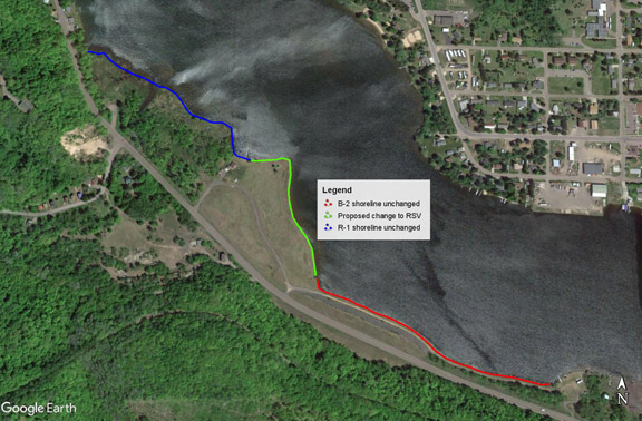
This map shows the locations and relative shoreline lengths for Parcel A (wetland, blue line), which remains zoned R-1; Parcels B and C (green line), proposed for rezoning from B-2 to Reserve (RSV); and Parcel D (red line), which is to remain zoned B-2. Across the Canal, Hancock's shoreline shows Hancock Beach across from the wetland as well as residential and some business properties across from the other parcels. Click on map for larger version. (Map © Google Earth and courtesy Liz Gerson)Liz Gerson, a concerned Houghton resident, offers an analysis of what the proposed rezoning and potential development would mean to her, illustrated by the Google map above: "The proposed zoning change to Reserve (RSV) involves about 11 acres (of 34 total acres for Parcels A-D), and relatively short stretches of Portage Canal road frontage and shoreline [green line on map]. Zoning for about 1/3 mile of shoreline remains in B-2 with conditions allowing for hotel, unrestricted in height [red line on map]. Directly across the Portage is primarily single family residential property in Hancock. It sounds like the prospective developer would fill this space with 18-24 two-bedroom vacation houses, which would maintain building heights comparable to R-1. If the developer's concept is realized, the daily occupancy level for the entire space will more than double what it would have been if built out at R-1. Otherwise, the plan seems fairly benign, and I personally have no objection to the partial zoning change to RSV, but will await further information from the public hearing."
The map below includes the approximate number of acres and the shoreline and road frontage lengths for each parcel.
Click here for the June 22 Planning Commission meeting packet, p. 9, and view a larger version of this map. (Map courtesy City of Houghton)Parcel D would remain in B-2 zoning, Bradway told Keweenaw Now, because it includes R-3, which permits multi-family residential.
Proposed Parcels B and C (about 10 acres) on these maps would be rezoned to Reserve for a campground that could include RVs as well as tents and would include a walking path.
Bradway describes this plan in his concept narrative: "Proposed development of an RV / tent campground. Planned are 46 modern, full hook-up RV sites and 23 Tent sites. Amenities include a 50' x 50' water's edge pavilion, docks for watercraft and fishing, a boat launch, and a playground. The campground will be nestled on the open, flat land. Campground construction is low-impact and minimally intrusive, thereby keeping the remediated site clean and stable. Approximately 350 trees will be planted. Green is good."

Bradway continues, "A walk path from the south end of the property to the north end of the campground along the water will be nearly 3/4 of a mile. A very nice, beautiful stroll."
This photo along Canal Road shows a view of Parcel C in the foreground, looking toward the Fodermaier property and the wetland. Click on photo for larger version. (Photo © Google Earth and courtesy Liz Gerson)Parcel A on the maps is the wetland bordering John and Bonnie Fodermaier's home. It includes the mouth of Cole's Creek and has remained in R-1 zoning.
This photo shows part of the wetland, viewed from the Fodermaiers' property on Portage Canal. (Keweenaw Now file photo)In his narrative, Bradway says this about the wetland: "A raised boardwalk, 1/3 of a mile in length, with observation outposts will be constructed on the land around the mouth of Cole's Creek. This 13-acre piece of land is to preserve the wetlands while giving access to all, including the public, to its beauty. Think of it as a smaller version of the Nara Nature Park."**
Bradway noted several environmental and local concerns in a recent conversation with Keweenaw Now.
"The boardwalk will meander in a natural, organic fashion through the entire wetland," Bradway said. "The wood we're going to use for the cabins, the boardwalk and things of that nature will be wood that is locally sourced."
He is planning on more than 300 trees to be planted on the property.
"The majority will be evergreen and some deciduous trees as well," he noted. "That gives better stability for that land as well."
The walking path is to be non-motorized.
"That's for pedestrian traffic only -- or bicycles," Bradway explained, noting the DNR motorized trail is on the opposite side of Canal Road for such vehicles.
Asked about parking, Bradway said individual parking spaces would be provided at the campsites and the vacation homes. Public parking for the boardwalk in Parcel A currently exists near the mouth of Cole's Creek.
Houghton resident Bill Deephouse, former Michigan DNR fisheries biologist, told Keweenaw Now the mouth of Cole's Creek, including the parking lot, has been owned by Dave Jukuri (of JRG) for a long time but was always open to anyone who wanted to use it.
"I sure hope that it will remain open to anglers of all stripes," Deephouse said. "Many times I have seen people out at the mouth in Portage Lake casting for salmon in the fall, and others fish there in the spring for steelhead. Smelting in the spring was a tradition here. But the smelt run has been very low in recent years. The creek always had a nice population of brook trout in it but that was before the 2018 flood. I wouldn't hazard a guess what it is like now short of having the DNR do a survey to assess what is still in the creek."
As mentioned above, Bradway said he intends to keep all of Parcel A open to the public. He also told Keweenaw Now that, previous to his agreement with JRG, Parcel A was under contract to a private individual who wanted to build a house on it. Fortunately that "pending sale" did not go through and Bradway was able to include the wetland in his potential purchase.
"We were a breath away from losing access to the entire 15 acres of wetland," Bradway noted. "Now we can continue to offer the creek for public access and enjoyment, as JRG has done in the past."
John and Bonnie Fodermaier, whose house is between Parcels A and B, are supportive of the rezoning proposal for Parcels B and C and Bradway's plan for the wetland adjacent to their residential property.
In a May 14, 2021 letter to the City of Houghton, Fodermaier writes, "The proposed zoning amendment is extremely compatible with the existing property surrounding the proposed site. The use of the land for an RV Park is in concert with the existing R-1 homes in the area. In addition, the Cole’s Creek
Wetlands would become a nature area open to the public with boardwalks and benches. This would preserve the wild bird nesting area and the trout stream in the best possible way."
Fodermaier notes also that he believes Bradway's proposal for the area will not have an adverse effect on property values. He lists benefits of the rezoning to include lower traffic levels than under B-2, lower light and noise pollution, seasonal impact (May to September only), and no large-scale excavation of the Superfund cover or potential exposure of hazardous materials.***
Also in support of the potential project are John and Suzanne Sanregret, who own property at the south end of Parcel D. In a May 24 letter to the Planning Commission, they state their support for the proposed campground and vacation lodging, noting these will be attractive to tourists with the proximity to the waterway as well as Downtown Houghton businesses and entertainment.
The City of Houghton's packet for the June 22 Planning Commission meeting lists Derek Bradway as manager of Gold Metal Rentals LLC in a May 15, 2021, document signed by F. Michelle Halley, the applicant's attorney.
In the Introduction to this document, Halley states, "JRG and Gold Metal Rentals currently have a Purchase Agreement with rezoning the property being a contingency of the sale. The Reserve District is designed for 'lands bordering the Portage Waterway.' Div. 10, § 98-127.
"Principal permitted uses include one-family dwellings, vacation cottages, and private or commercial recreation areas. Id. at 98-129. The Applicant’s proposed uses align with these allowed uses."
This document also includes discussion of 17 factors that are considered to determine whether the rezoning meets the goals of the City Zoning Ordinance and the Master Plan.
Some examples are Factor #5, which discusses the need for more camping facilities and vacation homes in the City of Houghton and Factor #9 on whether the physical characteristics of the site are appropriate for this proposed zoning amendment.
In answer to Factor #9, Halley writes,"The land is approved for development by both the U.S. Environmental Protection Agency (EPA) and the Michigan Division of Energy, Great Lakes and (EGLE). The applicable deed restrictions have been accounted for in this use proposal.
"Furthermore, campgrounds are low-impact and essentially non-invasive developments. The plans show 350 trees to be planted, which will enhance and stabilize this beautifully reclaimed land."****
Houghton City Manager Eric Waara presented the rezoning proposal from JRG to the Planning Commission at their May 25, 2021, meeting. According to the minutes of that meeting, Planning Commissioners made the following comments:
Kristine Bradof said she feels this is a good use of the property as it will not require a lot of digging and this is what Reserve is made for.
Jennifer Julien asked if it would create any problems by only rezoning Parcel B and Parcel C of the development and leaving Parcel A as R-1 and Parcel D as business. City Manager Waara said Parcel D can stay zoned as B-2 to fit the cabins. He does not see a problem with the smaller area rezoned to Reserve.
He said it is OK to only rezone the areas that need to be Reserve so it will not muddy the zoning.
Bill Leder asked if Mr. Bradway will add a deed restriction on Parcel A so that it remains open to the public. Mr. Bradway said he does not want to put a deed restriction on Parcel A. It is his plan to keep it open to the public.
At that May 25 meeting the Planning Commission voted unanimously to set a public hearing on this proposed Ordinance 2021-321 for Tuesday, June 22, 2021 at 5:30 p.m.
(See below for access to the June 22 meeting via Zoom.)*****
Bruce Woodry, a concerned Copper Country resident who was among the local citizens opposed to the original zoning change to B-2, told Keweenaw Now he had opposed the February rezoning to B-2 that would allow greater development on this Superfund property because of the strong potential for pollution from the construction site that could migrate to both ends of the Portage Canal. He agreed that this proposal for a campground and walking path in Parcels B and C would have less environmental impact. However, he remains concerned about public participation in the City of Houghton's decisions. He believes the City of Houghton officials do not always follow their own guidelines and procedures in approving zoning and do not respond appropriately to FOIA requests.
"They're not following their own rules," Bruce Woodry said.
He added that the Zoom meetings held because of COVID have helped to involve the public and he hopes all the meetings can continue to be on Zoom permanently to improve public participation.******
Attend Public Hearing via Zoom:
Join Zoom Meeting at https://us02web.zoom.us/j/84937327074
Meeting ID: 849 3732 7074
One tap mobile:
+13017158592,,84937327074# US (Washington DC)
+13126266799,,84937327074# US (Chicago)
Dial by your location:
+1 301 715 8592 US (Washington DC)
+1 312 626 6799 US (Chicago)
Meeting ID: 849 3732 7074
Notes:
* Click here for the June 22 Planning Commission Agenda.
** See p. 10 of the Agenda Packet for the June 22 meeting for Derek Bradway's complete narrative on the proposed development.
*** See p. 16 of the June 22 Agenda Packet for the Fodermaiers' full letter.
**** Attorney F. Michelle Halley's document is on pp. 11-14 of the Agenda Packet linked above.
***** The minutes for the May 25 Planning Commission meeting are on pp. 2-4 of the Agenda Packet linked above.
****** See the Bylaws for the City of Houghton Planning Commission, which include items on public participation. See also the 2019 City of Houghton Public Participation Plan, prepared by WUPPDR (Western Upper Peninsula Planning and Development Region).