By Danny Messinger, Tech Today student writer
HOUGHTON -- The Spring 2012 Women's Film Series will host a screening of The Secret Life of Bees at 7 p.m., Monday, Feb. 27, in Fisher 129 on the Michigan Tech campus.
The film, set in 1964 during the civil rights movement, follows a young girl as she flees from home with her caretaker to a South Carolina town, where they are taken in by three bee-keeping sisters. The film stars Queen Latifah, Alicia Keys, Dakota Fanning and Jennifer Hudson.
The screening is part of a monthly film series sponsored by Michigan Tech's Center for Diversity and Inclusion, the Women's Programming Committee and the Women's Leadership Council. Three more films are scheduled this semester.
The event is free and open to the public.
Friday, February 24, 2012
Keweenaw Krayons to hold Celebrity Krayon Auction at Vertin Gallery Feb. 25
 MOHAWK -- Keweenaw Krayons is hosting their first Celebrity Krayon Auction at 6 p.m. Saturday, Feb. 25, at the Vertin Gallery in Calumet.
Barbara Rose, Keweenaw Community Foundation executive director, will auction off pieces of "crayon" art created by local artists, businesses and community leaders.
Visit keweenawkrayons.com for more information. See examples of the art on their Facebook page.
Woods Person: Potential Impact of Waste Rock and Tailings Volumes in the Proposed Gogebic Open Pit Mine
Posted by Woods Person
Feb. 23, 2012
Reprinted with permission
NORTHERN WISCONSIN -- The WoodsPerson blog reports working for some time to project the volumes of waste rock and tailings from phase 1 of the proposed GTac mine. Phase 1 would be a mine up to 4.5 miles long, ¼ to ½ mile wide and 900 feet deep. Initial calculations, previously published below, have been refined and confirmed as "reasonable" by four geologists and one mining engineer.
 A waste rock pile approximately 200' high. Note ore train in foreground. (Photo courtesy Woods Person)
The purpose of doing these calculations is to emphasize the enormity of this project and to put it into some common frame of reference. Whether one is for, against, or neutral to mining or this mine, an understanding of its scope is important.
The calculations are based on a section study of the Ironwood Formation done in 1929 at the Tyler Forks River and use of the Google Earth program’s elevation feature to determine terrain. These scientists used Solidworks 3D solids modeling software to create a dynamic three dimensional model of the deposit and its surroundings. The dynamic nature of the model allows changing such parameters as terrain, angle of pit walls, width of deposit and the like, as additional information is made available.
Click here to read the rest of this article on woodsperson.blogspot.com.
From Stand for the Land: O’dewe’igan Negaunee Giishik
Posted on Stand for the Land
Feb. 23, 2012
Reprinted with permission
What is occurring across our territory is overwhelming and way bigger than a single mine or a road, and the approval of this road under the disguise of the Marquette County Road Commission represents the road to destruction, just as the ancient Anishinaabe prophecies teach. We are the new people. Humanity has a choice. Anishinaabe people have an obligation.
This road should not be a discussion.
This road should not be paid for by taxpayers.
This road should not come before re-building and fixing existing roads.
This road should not be built…. period.
Rio Tinto should not invest their money in this road and or the Eagle project. This proposed road will be a waste of time, effort and resources. It is in fact a haul road for Rio Tinto.
O’dewe-igan negaunee giishik means "mother earth's heartbeat right before sunrise." Negaunee means leading, or right before…. Ishpeming means after, or up there. We are sitting right now on ceded territory…Native land… Anishinaabeg land.
Please study the US constitution. The United States Constitution provides that "Congress shall have Power . . . to regulate commerce . . . with the Indian Tribes." No mention of "State" control.
Please study the 1836 and 1842 treaties -- they also refer to us as a Nation. The Indians stipulate for the right of hunting, gathering, trapping, cultural practices on the ceded territory, with the other usual privileges of occupancy, until required to remove by the President of the United States… I don’t think that has happened yet, has it?
Please understand that the Eagle Project and this haul road are both illegal. If you agree with the Eagle Project and agree with this haul road being built, you are guilty as well.
Read the Anishinaabe 7th Fire Prophecy. This road and the Eagle Mine represent the Path of Destruction. (Mishomis Book Chapter 13.)
The Anishinaabeg are a nation, not a state. We’re not supposed to be discussing our lands and way of life with the states. We’re only supposed to discuss these issues with the federal government.
If you are a true human being you will understand this truth. Stop assisting, stop aiding and abetting. Stop violating our land and our way of life.
Start inviting us to your table so we can discuss these matters. We are the true stewards of this land; our women are the keepers of the water. We offer to let you use it, walk about it as you please. Just respect it; you can’t do anything you want on our land.
Free, Prior, and Informed Consent, from the U.N. Declaration on the Rights of Indigenous Peoples -- this means you need our approval, and you don’t have it…and you don’t listen.
What’s taking place is wrong.
We as a people are not against "jobs." We are all for "jobs" when it/they are done right, when it respects all people's views…our views, our concerns. We are strongly against desecrating our land, our Mother Earth. We feel disrespected that the State of Michigan will not listen to our just pleas.
Everybody, please, do the right thing. Follow the proper path.
The fact that the billion-dollar ore deposit at Eagle symbolizes a baby is pretty significant. It represents the womb of Mother Earth. The Anishinaabe people have prophecies telling of this time when humanity must choose between two paths. Look at all of the destruction happening to the entire Earth. Eagle Rock is a shining example of this choice….spiritualism or technology/destruction? Sacred Site or Mine Portal?
Miigwech.
Dave Mayo
Keweenaw Bay Indian Community Tribal Member
for O’dewe’igan Negaunee Giishik
WMTU to celebrate renovations with Open House Feb. 24
HOUGHTON -- Michigan Tech’s student-run radio station, WMTU, has done a complete remodel and renovation and invites the public to check out the results. An Open House will be held from noon to 6 p.m. Friday, Feb. 24, at the station, located in Wadsworth Hall G03W (on the west side of the basement).
According to WMTU staff member George Olszewski, they have "completely renovated the show-host booth, repainted the walls, replaced lighting, changed the layout, and bought a new counter-top."
Another major change is the new soundboard, which cost $16,000, he said.
"This replaced an eleven-year-old system that was beginning to fail. The whole project cost approximately $27,000," Olszewski added.
Olszewski said staff members will be hosting station tours, broadcasting live during the Open House, and will have drinks and snacks. Staff members will be on hand to answer questions and discuss the station and the renovation project.
WMTU started as a residence hall-only station in the 1950s. It has grown to include some 100 hosts and forty staff members, making it one of the largest student organizations at Michigan Tech. WMTU broadcasts at 91.9 FM and is also involved in events throughout the year, including the Keweenawsomefest music festival each spring.
Thursday, February 23, 2012
Mardi Gras Masquerade Dance to feature music by Backroom Boys, dance lessons Feb. 25
 Poster for Mardi Gras Masquerade Dance to be held from 6 p.m. to midnight Saturday, Feb. 25, at the Little Gem Theater in Lake Linden. Click on image for larger version. (Poster courtesy Keweenaw Social Dance)
LAKE LINDEN -- Keweenaw Social Dance will hold a Mardi Gras Masquerade Dance this Saturday, Feb. 25, at the Little Gem Theater in Lake Linden.
The doors open at 6 p.m. and live music by the Backroom Boys begins at 6:30 p.m. Professional dance lessons will be offered by Chistian Laun and Charles Hill at 6:30p.m. on the 3rd floor.
Admission for couples is $10; singles $6.
Wear a mask (and/or costume) if you wish to be eligible for a surprise at the Unmasking, 11 p.m. If you need masks or beads, they will also be for sale at the door. If you want to get some before the dance date, make sure to call 906.370.9532 or email Charles Hill at keweenawsd@gmail.com. Traditional colors are purple, green, and gold but sky's the limit! Also, if transportation is an issue, let Charles know!
The Little Gem Theater is at 700 Calumet St., Lake Linden (former school building).
Carnegie Museum to host presentation on Isle Royale historic mines Feb. 23
HOUGHTON -- Like the Keweenaw Peninsula, Isle Royale was once home to mining companies searching for deposits of pure, elemental copper. Join Seth DePasqual, cultural resource manager at Isle Royale National Park, as he shares this rich history and the challenges faced by those willing enough to mine on this remote island.
This event will be held at 7 p.m. TONIGHT, Thursday, Feb. 23, at the Carnegie Museum, located at 105 Huron Street in Houghton.
DePasqual has spent several years studying and documenting historic mines in the Keweenaw and on Isle Royale. Learning about these mines, the people who once worked and lived at them, and the technology they used to extract ore, helps the park preserve and interpret their history to visitors. It also provides a more complete understanding of the history of native copper mining throughout the Keweenaw.
For more information, including specific directions to the event, please call Keweenaw National Historical Park at 906/337-3168 or visit www.nps.gov/kewe.
The Fourth Thursday in History series arranges public presentations on important aspects of Copper Country and regional history, including techniques for historic preservation. Presentations are scheduled in venues throughout the Keweenaw Peninsula, particularly at historic sites associated with specific topics. They are free and open to the public.
This program will be held downstairs in the Carnegie Museum's Community Room. Both upper and lower entrances will be open at 6:45 p.m. Parking is available in the rear of the building or in the City lot across Montezuma Avenue. For more information, email history@cityofhoughton.com or call 482-7140.
Khana Khazana to join African Students Organization Celebration this week
 The Adinkra Dance Ensemble, who trace their roots to Ghana, perform during the 2011 African Night celebration in the Rozsa Center. This lively, energetic group will return for this year's African Night performance Saturday, Feb. 25, in the Rozsa. (Keweenaw Now file photo)
HOUGHTON -- African Night, hosted by the African Students Organization (ASO) on Saturday, Feb. 25, at the Rozsa Center is the grand finale to Michigan Tech's Black History Month activities. The entertainment begins at 7:30 p.m. and will feature guest performers -- the Adinkra Dance Ensemble, who trace their roots to Ghana.
Admission is $6 for all students, $10 for faculty and general public and free for children under age 5. All tickets are performance only. For tickets call 487-2073 or go to rozsa.tickets.mtu.edu.
This year Khana Khazana (food treasure) will serve African cuisine during their Friday lunch on Feb. 24. ASO members will be donning chef's hats and aprons to cook an authentic African lunch for Khana Khazana.
The lunch will be served from 11 a.m. to 2 p.m. Friday, Feb. 24, in the Memorial Union Food Court. Dishes will include samosas, spicy stuffed pastry appetizers; waakye, a traditional bean-and-rice dish from northern Ghana; and spicy baked chicken. A full meal costs $6; individual entrees are available for $2 each. A full meal includes free coffee, hot tea or fountain soda. Vegetarian food is also available on request.
Khana Khazana, a weekly series of international lunches, is a collaborative effort of international students and Michigan Tech Dining Services.
Wednesday, February 22, 2012
Updated: Headwaters: Citizens Pack Hearing to Oppose Rio Tinto Road
 At the Feb. 21, 2012, DEQ Hearing in Ishpeming, James Haun of Skanee speaks of his opposition to the proposed CR 595. Haun, a Vietnam veteran, said he learned about the U.P. from a fellow soldier in a bunker in Vietnam and came to this beautiful area right after the war, determined to spend the rest of his life here. (Photo © and courtesy Jeremiah Eagle Eye. Used here with permission.)
By Gabriel Caplett
Posted Feb. 22, 2012
ISHPEMING -- Hundreds of citizens packed a conference center in Ishpeming on Tuesday, Feb. 21, 2012, to give their opinions on a proposed "County Road 595" mine hauling project, in western Marquette County. Of 61 speakers, a majority -- 34 -- (including this author) criticized the road project, with most support for the project coming from area politicians and industry representatives.
 Wildcat Canyon in the potential CR 595 corridor. Looking straight down the canyon, one can see Eagle Rock in the middle of the photo, close to the top, below the bluish ridges on the horizon. The sand from the Eagle Mine site is visible just to the right and left. Click on photo for larger version. (Photo © and courtesy Jeremiah Eagle Eye. Used here with permission.)
Bill Malmsten, an Ishpeming resident and president of the Upper Peninsula Environmental Coalition, summed up a sentiment commonly heard throughout the Michigan Department of Environmental Quality hearing.
 This Marquette County Road Commission map shows a detail of the area where the proposed CR 595 compares to the Woodland Road, previously proposed by Rio Tinto-Kennecott as a private mine haul road. The yellow line is the Woodland Road with the red line showing CR 595 route slightly east of it. The dark line (most of the route) indicates where the routes coincide. Click on map for larger version. (Keweenaw Now file photo)
"I’m pretty sure that there isn’t a person in this room who doesn’t understand that the real purpose of the County Road 595 proposal is not what’s stated in the wetland application, that it’s no coincidence that 595 would start at Kennecott’s mill and end at Kennecott’s mine, that’s it’s no coincidence that the 595 route follows almost the exact same route as the previously proposed mine haul road," said Malmsten.
Click here to read the rest of this article on Headwaters News.
Proposed open pit Pebble Mine threatens important Alaska salmon fishery
 Image from poster for the documentary Red Gold: the Pebble Mine Debate courtesy Keweenaw Bay Indian Community (KBIC) Department of Natural Resources, who sponsored a showing of this film last November in Baraga as part of KBIC's "Mining Impacts on Native Lands" Film Series. This week the film was hosted in Hancock by the Copper Country Chapter of Trout Unlimited and two visiting Alaskan dog mushers, Monica Zappa and Tim Osma.
By Carol Johnson Pfefferkorn*
HANCOCK -- Bristol Bay, Alaska, described as a "gem in a jewel," is being threatened by a potential open pit mine called Pebble Mine. Last night, Feb. 21, at the Orpheum Theater in Hancock, the Copper Country Chapter of Trout Unlimited (CCCTU) hosted two Alaskan dog mushers, Monica Zappa and Tim Osmar, who have decked their sleds, truck and dog coats, and traveled thousands of miles to bring attention to the dangers to Bristol Bay from an open pit mining proposal. They raced in the UP 200 dogsled race and hosted three screenings of a documentary, Red Gold: the Pebble Mine Debate, about Bristol Bay.
According to SaveBristolBay.org., "The Pebble deposit is a massive storehouse of gold, copper and molybdenum, located in the headwaters of the Kvichak and Nushagak Rivers, two of the eight major rivers that feed Bristol Bay. If built, Pebble would be one of the largest mines in the world. Because of its size, geochemistry and location, Pebble runs a high risk of polluting Bristol Bay, one of the world’s few and most productive wild salmon strongholds that supports a $500 million commercial and sport fishery. For this reason, Trout Unlimited is working with a diverse group of fishermen, guides, lodge owners, Alaska Natives, scientists, chef, restaurant owners, seafood lovers and many others to try to stop the Pebble development and to protect Bristol Bay."**
 In this scene from the documentary Red Gold, a Native fisherman prepares salmon filets for preservation. Two visiting Alaskan dog mushers, Monica Zappa and Tim Osmar, along with the Copper Country Chapter of Trout Unlimited, hosted the showing of the film in Hancock's Orpheum Theater on Feb. 21, 2012. (Photo by Keweenaw Now)
Save Bristol Bay also notes the proposed mine developers, the Pebble Limited Partnership (PLP), are a consortium of the world’s second largest multinational mining corporation, London-based Anglo American, and Northern Dynasty, a junior mining company headquartered in Canada.
Opponents of the mine are critical of Anglo American’s environmental track record Northern Dynasty's lack of environmental experience since it has never before developed a mine. PLP's preliminary designs indicate that the Pebble Mine complex would span 20 square miles of state land in the Bristol Bay watershed. The proposed mine -- an open pit up to 4,000 feet deep and 2.3 miles wide -- would produce up to 10.8 billion tons of waste rock, resulting in one or more of the world’s largest tailings storage facilities.
"Located in a seismically active region, Pebble would require the world’s largest earthen dam to be built, some 700 feet high and several miles in length. Independent scientists have questioned whether the dam could withstand the force of a massive earthquake, such as the 9.2 quake that devastated Anchorage in 1964."**
The Wild Salmon Center and Trout Unlimited have produced a report examining the proposed Pebble Mine and its potential impacts on the wild salmon fishery of Bristol Bay.
Examining a wide body of studies, reports, and the best available scientific information, the report analyzes preliminary proposals for the mine, concluding there is too much at stake ecologically, economically, and culturally to risk development of the Pebble deposit.***
Preliminary proposals and studies presented by developers indicate that the Pebble Mine:
- contains ore that has a high likelihood of generating acid mine drainage, which is severely harmful to salmon and other aquatic species;
- will produce up to 10.8 billion tons of waste rock, requiring miles of tailings dams initially proposed up to 740 feet high;
- may use 35 billion gallons of fresh water per year, more than three times the usage of Anchorage, Alaska’s largest city; and
- will construct multiple sources of contamination, including: an open pit and underground mine, an 86 mile road and pipeline route, a deep-water port and other infrastructure.
An unprecedented coalition of Alaska Native tribes and corporations, sportsmen, commercial fishermen and others have asked the EPA to protect Bristol Bay by withdrawing the watershed as a disposal site for dredge and fill activities under Section 404(c) of the Clean Water Act. The EPA is currently conducting a scientific assessment of the Bristol Bay watershed to determine whether large-scale development would adversely impact the region’s natural resources.
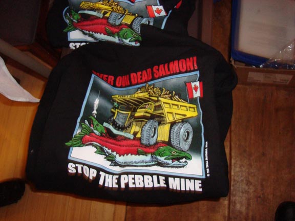 T-shirts for sale at the film showing depict the proposed Pebble Mine's threat to Bristol Bay's wild salmon fishery. (Photo by Keweenaw Now)
The documentary Red Gold describes Bristol Bay, with its commercial and sports fishery, as a fully-functioning ecosystem that would be destroyed by the proposed Pebble Mine. The film shows all sides of the debate -- from industry officials to the people of Bristol Bay -- Native, commercial and sport fishermen -- whose way of life depends on this important fishery.
A representative of Northern Dynasty Mines, interviewed in the film, said, "We will not be swayed by environmentalists who say we will cause an ecological disaster. Fish can exist right alongside the copper mine. It will not destroy the fish."
Mayor Ole, self-proclaimed mayor of Bristol Bay, said, "This is just a wrong idea in the wrong place."
At a "Stop the Pebble Mine" rally, local residents urged state and federal lawmakers to defeat the proposal, saying this mine would change their lives forever.
"Salmon are a part of our life. We were raised by salmon. It’s where we come from, what we were born to," residents said.
About 60 people watched the film in the Orpheum Theater. Many enjoyed free beer and pizza during the introduction by the visiting dog mushers. Afterwards some expressed their impressions of the film.
Tom Rozich, President of the Copper Country Chapter of Trout Unlimited, said he felt the documentary was well done, gave equal time to both sides, and offered enough information so that individuals will be able to make an informed decision about open pit mining.
Personally, Rozich added, he feels that, using current technology, Pebble Mine is not going anywhere. The mine waste generated would ruin the fragile environment, which is not acceptable.
However, he noted that some day, once technology improves to the point that mining can occur safely, without hurting the environment, without destroying waters and wildlife, it will happen.
Houghton resident Jim Curtis said, "Somehow we have to figure out how we can get the resources we need without ruining the environment. Mining has a huge impact on our society."
Notes:
* Keweenaw Now guest writer Carol Johnson Pfefferkorn recently moved to the Keweenaw from the Menominee area. In addition to writing, she is assisting Keweenaw Now with advertising and public relations.
** See savebristolbay.org to read more about the Pebble Mine.
*** Click here for a summary of the report. To download a full copy of the report, click here.
Ski club, KLT to host old-time skiing at Churning Rapids Feb. 25
HANCOCK -- Join Keweenaw Nordic Ski Club (KNSC) and Keweenaw Land Trust (KLT) at Churning Rapids for some old-time skiing Saturday, Feb. 25.
Between Noon and 3 p.m. Saturday skiers will gather near the Lookout Landing Observation Tower along the No. 10 Thoroughfare Trail (trail map available at http://www.keweenawnordic.org/trail-map/). There will be a fire and chili to warm you and a lavvu will be set up (What's a lavvu? check out lavvu.com). Knickers, wool sweaters, wood skis and bamboo poles are not required, but skiers are encouraged to use them if they have them. Skiing too will be the old way -- breaking trail in the woods!
 Gromit, the Maasto Hiihto-Churning Rapids snow dog, demonstrates breaking trail in the woods. See her Trail Mutt Reports for more photos. (Photo © and courtesy Arlyn Aronson)
Don't let that discourage you! Bring a friend or two -- the more the merrier and less trail breaking to do! No fee but donations are appreciated and will be split evenly between the Keweenaw Cross Country Ski Endowment at the Keweenaw Community Foundation and KLT's Land Stewardship Fund. Ski in on your own from the Christensen Road trailhead (approximately 2 mi.) or the Tomasi trailhead (approx. 2.5 mi.). Check the tower location on the trail map at the trailheads; skiers will be gathered about 0.1 miles from the tower toward the Christensen Road trailhead on the Thoroughfare trail.
Driving directions: From Hancock take M203 approximately four miles to Christensen Road. Turn right into the parking area.
A heads-up on numbers would be appreciated so there is enough chili for everyone. Please call Jay at 487-5411 or email at jbgreen45@charter.net to let him know the number of skiers in your party or if you have any questions.
Tuesday, February 21, 2012
Updated: Letter: Scientists offer evidence of sulfides in Penokee mine site
To the editor,
Definitive evidence exists that sulfides are present in the Penokee mine site, possibly in sufficient quantities to pollute the Bad River Watershed with acid mine drainage. In fact, the presence of pyrite (iron sulfide) in the Ironwood Formation was noted in a Wisconsin Geologic Survey in 1929 (Aldrich, 206-212) and again now by three active geologists.
To create a separate ferrous mining bill that allows a mining company to "do their best" if they encounter sulfides and disallows scientists to testify in contested case hearings is irresponsible stewardship of our state’s natural resources. Sulfides can occur anywhere, and when combined with iron (as in pyrite), oxygen, and water, the result is sulfuric acid. In his testimony at Friday’s (Feb. 17 in Madison) Joint Finance Committee hearing, Jason Huberty (MS Geology) explained that you can’t distinguish between ferrous and nonferrous ore. By doing so, as in the proposed law AB426, the existence of sulfide minerals in the iron ore is hidden (With).
Why, then should iron mining be excused from so many rules when, in fact, the risk of acid mine drainage is present?
When Gogebic Taconite explains that no chemicals will be needed in their mining operation, they are not talking about mining but about the processing of the taconite -- separating magnetite from the ore using water and magnets after that ore has been mined. But, it is the actual mining of the ore -- blasting the overburden and removing the ore from the earth -- that exposes the pyrite to water and air at a much faster rate than would occur naturally, thus accelerating the acid production.
Marcia Bjornerud, PhD, Geology Professor, Lawrence University, after studying the area for 25 years, discovered that there are sulfide minerals in the overburden directly above the iron deposit targeted by the proposed GTac mine. When that waste rock is removed and then stored in piles in the mining process, the disseminated pyrite in the fragmented rock would over time be oxidized and interact with rain and snow, leading to acid drainage (Bjornerud).
Further, geochemist Joseph Skulan testified that after personally analyzing samples of the rock, some of which contained 20 percent pyrite, he concludes that billions of gallons of sulfuric acid could be produced (With).
In conclusion, because of sulfides present, the potential exists for acid mine drainage from the GTac mine into the Bad River Watershed. Therefore, it is irresponsible to enact a law, such as AB426, which separates ferrous and nonferrous mining, since both types have the same potential for environmental damage.
Thank you for your attention to this matter.
Sources:
Aldrich, H.R., 1929. The Geology of the Gogebic Iron Range in Wisconsin. Wisconsin Geologic survey.
Bjornerud, Marcia. 12/18/2011, savethewatersedge.com.**
With, Barbara. 2/18/2012, "Façade of 'Responsible Mining' Crumbles; New Mining Bill Proven to Mislead the Public."*
Wendy Thiede
Oma, WI
*Editor's Note: See also a video clip of the two geologists' testimonies at the Feb. 17, 2012, meeting in Madison.
** Update/clarification: Dr. Bjornerud made these comments after the Assembly hearing in December 2011 (in West Allis, near Milwaukee), not at the Feb. 17, 2012, hearing. They were posted Dec. 18, 2011, on savethewatersedge.com.
Finlandia Student Nurses to host Spaghetti Dinner benefit for Omega House
HANCOCK -- The Finlandia University Student Nurses Association will host a Spaghetti Dinner from 4 p.m. to 7 p.m. Saturday, Feb. 25, 2012, at Saints Peter and Paul Evangelical Lutheran Church, Houghton.
Proceeds from the dinner will benefit the Omega House Hospice, Houghton.
On the menu are spaghetti with meat sauce, salad, bread, home-baked goods, coffee, tea, and punch. A raffle will also be held, featuring items and gift certificates from local businesses and community members.
This is the seventh year the student nurses have hosted a Spaghetti Dinner fundraiser to benefit the Omega House. In the first six events, over $13,000 was raised.
Tickets are $7 for adults, $3 for children ages five to ten, and free for children under age five. Tickets can be purchased in advance from Finlandia student nurses or at the door.
Carry-out meals will be available.
The Finlandia University Student Nurses’ Association engages in a number of community activities throughout the year. They include community-wide canned food drives, blood drives, breast cancer and domestic violence awareness activities, donation of holiday gifts to the Salvation Army, and assisting fellow student nurses with speakers and special review courses.
For tickets or information, please e-mail anconstable@fu.edu.
Raffle tickets are $2 each or 3 tickets for $5.
UPEC to host forum on eminent domain or state condemnation of private land Feb. 29
MARQUETTE -- The Upper Peninsula Environmental Coalition (UPEC) announces an open forum on eminent domain, or the right of public authorities to condemn private land for public purposes, including road-building and economic development. It will be held at 7 p.m. on Wednesday, Feb. 29, at the Federated Women’s Clubhouse, corner of Ridge and Front streets in Marquette.
Condemning private land is one hammer in the toolbox of public authorities for achieving their goals. It has surfaced as an issue in the proposed County Road 595, which is no longer a private mining haul road but a public road spearheaded by the Marquette County Road Commission. Is this tool likely to be used? This free public forum will allow a thorough exploration of this issue.
The facilitator will be Dr. Phil Bellfy, a Native American educator, author, and Michigan State University professor, who has studied the use and abuse of eminent domain in the Lansing area. Based on Bellfy's experience and research, he will explain the laws, address the standards introduced in the 2006 state constitutional referendum, and illustrate through case studies how eminent domain has been practiced in Michigan. For more information, contact Jon Saari at 906-228-4656.
Monday, February 20, 2012
Updated: DEQ to hold public hearing on CR 595 Feb. 21
By Michele Bourdieu
 Marquette County Road commissioners take public comments on the proposed County Road 595 during their Sept. 19, 2011, meeting in Ishpeming. Since then the Road Commission has submitted a permit application to the Michigan Department of Environmental Quality (DEQ) for the road's environmental impacts. The public will have another chance to comment on the road and that application during a DEQ Hearing on the application tomorrow, Tuesday, Feb. 21. (Photos by Keweenaw Now)
ISHPEMING -- Marquette County Road Commission (MCRC) Engineer Manager Jim Iwanicki says he expects a large crowd will attend the Michigan Department of Environmental Quality (DEQ) Public Hearing tomorrow, Tuesday, Feb. 21, on the Road Commission's application for permitting County Road 595, a proposed 21-mile road to connect US-41 with County Road AAA.
The DEQ will host the public hearing to receive comments on the proposal beginning at 6 p.m. at the Country Village Banquet and Conference Center, 1011 North Road, in Ishpeming.
The Marquette County Road Commission’s stated purpose is to construct a new primary county road that will improve emergency, commercial, industrial, and recreational access to northwest Marquette County and reduce truck travel through Marquette County’s population centers.
The proposed road project connecting US-41 near Humboldt to County Road AAA near Kennecott’s Eagle Mine requires wetland, inland lake and stream, and floodplain permits. The DEQ has determined the Road Commission’s application is administratively complete.*
Critics of the road consider it chiefly a haul road for Rio Tinto-Kennecott's Eagle Mine and claim the stated purpose of the road is poorly defined, as stated in a Feb. 17, 2012, posting on Stand for the Land:
"This is a haul road for Kennecott," the article states. "It is a nearly direct route from Kennecott’s Eagle Mine to their processing facility in Humboldt. Kennecott has invested over $8 million in the project so far, and has offered to pay for construction of the road. There is no previously documented public need for this road, while Kennecott’s mine permit application shows they considered the possibility of a south haul route as far back as 2006."**
In their application to the DEQ, the Road Commission states the purpose of the road as follows:
"The purpose of the proposed CR 595 project is to construct a primary county north-south road that 1.) connects and improves emergency, commercial, industrial and recreational access to a somewhat isolated but key industrial, commercial and recreational area in northwest Marquette County to US-41; and 2.) reduces truck travel from this area through Marquette County population centers."
The application also quotes an Oct. 4, 2010, letter to James Iwanicki from Gerald O. Corkin, Chairman of the Marquette County Board of Commissioners, stating, "'there would be many public benefits from the new road. The road would improve access to recreation land, western Marquette County businesses would benefit from a safe, efficient transportation route, and truck traffic from the Kennecott mine would use the new road rather than US-41/M-28, CR510, CR 550, CR 492, CR 502, and CR 473, improving safety on existing state highways and county roads. In addition, the new road would greatly benefit the timber industry.'"
The fact that the mining and timber industries would be the major beneficiaries of this road was clear at the Sept. 19, 2011, MCRC meeting, where a sort of parade float featuring the mining and logging industries as the future of the U.P. welcomed the public to the meeting at the Ishpeming Township Hall.
 This "float" promoting mining and logging, was parked in front of the Ishpeming Township Hall on Sept. 19, 2011, preceding the Marquette County Road Commission meeting taking public comments on the proposed CR 595 that day.
The sponsors of this exhibition were announced on a large sign that was part of this display:
 The names of Michigan Republican elected officials are displayed as supporters of logging and mining in an exhibit outside the Ishpeming Township Hall preceding the meeting of the Marquette County Road Commission on Sept. 19, 2011. Click on photo for larger version.
Under "Purpose and Need," the application appears to confirm the emphasis on mining and logging in this statement:
"Logging and mining have been integral to the base economy of Marquette County and the entire western Upper Peninsula since settlement. The value of the logging and mining industries to this region is significant. Much of the infrastructure in Marquette County can be attributed to these two industries; including roads, power plants and hydropower facilities, recreation amenities, and public services. This proposed project, the construction of a new primary county road to serve these two heritage industries as well as providing access to lands for recreation and other public benefits, is essential public infrastructure to continue to support these baseline industries that form and sustain the region’s economy. The full economic benefits of the mining and logging industries cannot be realized without the proposed road."
Keweenaw Now asked Iwanicki today how this road, which will be used for a large number of mining and logging trucks, will also serve "recreation."
In their DEQ application MCRC estimates more than 50 round trips per day of ore trucks will be added to existing traffic volumes on primary county roads and US-41 depending on the selected route of truck traffic to and from the mine. (See section 3.03 of application.)
A chart displayed at the Sept. 19, 2011, meeting shows estimates of logging traffic:
 In the application document, this is Table 3-1. Timber Company Activities and Annual Estimated Level of Use for CR 595. Click on photo for larger version or see the MCRC application to the DEQ, Section 3.
Iwanicki said the primary benefit to recreation is access to trails, e.g., a turn-off that leads to the North Country Trail. In addition it will provide easier access tor CFR (commercial forestry) land, which is open to the public for certain activities such as hunting and fishing.
At the Sept. 19, 2011, MCRC meeting Iwanicki reviewed the resolution passed by the Board of Marquette County Road Commissioners in 2010 approving the need for a new road running north-south from County Road FY/US41 to County Road IAA and discussed resolution updates since that time. He also read his recommendations to the Road Commission Board:
At the Sept. 19, 2011, Marquette County Road Commission (MCRC) meeting, MCRC Engineer Manager Jim Iwanicki reviews the resolution approving the need for the proposed CR 595 and gives his recommendations to the MCRC Board. (Videos by Allan Baker for Keweenaw Now)
Iwanicki told Keweenaw Now today, Feb. 20, that the content of his presentation at that Sept. 19 meeting is still current in the application, though some additional work has been done on it since that meeting. Iwanicki said he would be giving a similar presentation at the DEQ Hearing tomorrow, Feb. 21, in Ishpeming.
The application also indicates both support and criticism of the CR 595 project.
At the Sept. 19, 2011, MCRC meeting, public comments from supporters included several township supervisors or representatives and State Sen. Tom Casperson, State Rep. Matt Huuki, and a representative for Congressman Dan Benishek. A few questions came from members of environmental groups and other local residents.
During the Sept. 19, 2011, MCRC meeting, representatives of townships and construction companies express support for CR 595. Cynthia Pryor of the Yellow Dog Watershed Preserve asks for more detail and requests that the Road Commission put all information and updates on the road online. Presently, the entire DEQ application is online on their Web site and an almost identical document is on the MCRC Web site.
A representative for U.S. Congressman Dan Benishek (R-Crystal Falls) reads Benishek's statement of support for CR 595 during the Sept. 19, 2011, MCRC meeting.
Michigan State Sen. Tom Casperson (R-Escanaba) and State Rep. Matt Huuki (R-Atlantic Mine) offer their comments of support for CR 595, while Steve Garske questions the need for the road since Kennecott's original application for the mining permit including transporting the ore to a railhead.
Gail Griffith, retired Northern Michigan University professor and member of Save the Wild UP, asked if federal highway funds would be involved for this road and if so would there be an appropriate NEPA (National Environmental Policy Act) environmental impact statement.
"As of now the Road Commission is not planning to use any federal highway funds," Iwanicki replied."And if we do there are other things that have to be done that are involved with federal highway funds."
Environmental impacts are the reason for the application to the DEQ. The application states the following:
"The proposed CR 595 would result in the total wetland impacts of 25.81 acres of wetlands over a distance of 21.4 miles. Included in the total wetland impacts for the CR 595 project are impacts to 0.35 acres of wetland associated with the necessary relocation of snowmobile Trail 5 (the application for permit to be filed for by others) and 0.01 acre of wetland impact associated with the East Branch Salmon Trout River stream mitigation project. Also, there are 22 stream crossings (bridges or concrete box culverts) along the proposed CR 595 and one stream crossing on the East Branch Salmon Trout River stream mitigation project." (See Section 4, CR 595 Project Overview in the application)
The Nature Conservancy, which holds a conservation easement in an area near the proposed road, has sent two letters to the Road Commission concerning one of their initial alternatives for the road route.
In their Jan. 5, 2012, letter, TNC states, "The Nature Conservancy is strongly opposed to Alternative 12A, the Mulligan Plains West Route,since it would violate the terms of a recorded conservation easement and would cause destruction and fragmentation of important conservation resources."
While the Mulligan Plains West Route is still mentioned on the application as a possible alternative, Iwanicki said today that the Road Commission has now eliminated that option.
"Our board has no interest at all in building a road through Nature Conservancy property," he said.
MCRC's preferred alternative at present is the Kipple Creek option, which follows a logging road known as Snowmobile Trail #5.***
He explained the need to list alternatives in the application in case the DEQ (or federal agencies involved) should object to the preferred alternative.
"We submit an application for our preferred alternative, but in justifying that preferred alternative we had to show other things that were considered and why those things considered don't meet the project purpose."
Despite MCRC's plan to create new wetlands as mitigation for those the road would impact, environmental groups opposed to CR 595 claim the destruction of wetlands could be greatly reduced by the use of existing roads.
As the article in Stand for the Land notes, "Construction of County Road 595 would cause severe and widespread adverse impacts to the environment. The proposed action will result in degradation and destruction of aquatic ecosystems, waters, and associated natural resources. Wetlands mitigation has a high rate of failure. The activity is not wetland dependent. There are available alternatives that would meet the purpose and need stated in the 595 application. Updating Kennecott’s permitted haul route (Triple A-510-550) and continuing to use other existing roads would result in wetlands impacts of only about one acre."
Because of the impacts to wetlands and streams in this project, federal agencies that objected to the original Woodland Road proposed by Kennecott (CR595 is about 75 percent the same route as the proposed Woodland Road), i.e., the Environmental Protection Agency (EPA), the Army Corps of Engineers and the U.S. Fish and Wildlife Service, are still involved with this project, even though Michigan is one of only two states (the other is New Jersey) that evaluate environmental permit applications normally regulated by federal agencies.
"The DEQ has responsibility for federal permitting," Iwanicki noted, "but because of the nature of this project and because of the amount of wetlands being impacted, the Army Corps, EPA and U.S. Fish and Wildlife Commission weigh in and give their opinions to the DEQ."
The MCRC application to the DEQ includes five wetland mitigation sites described in section 8, including maps of each one.
Written public comments, accepted through March 2, should be sent to DEQ, 420 5th Street, Gwinn, MI 49841.
The public can also submit comments electronically by filling out this DEQ form.
Comments can also be submitted to these agencies:
US EPA, Region 5 Watersheds and Wetlands Branch 77 West Jackson Boulevard Chicago, IL 60604
Army Corps of Engineers at: US Army Corps 477 Michigan Ave. Detroit, MI 48226
Notes:
* Click here to access the application on the DEQ Web site or click here to download the entire pdf file of the application.
** Click here to read the Feb. 17, 2012, Stand for the Land article, "DEQ Hearing on CR 595, aka Kennecott's haul road."
See also "Rio Tinto continues to push for Wilderness haul road."
Update: Click here for maps of the CR 595 preferred route.
Update: See also Lake Superior Mining News for more info on CR 595.
Bad River Watershed Association to present Penokee area baseline water quality study results Feb. 21
MELLEN, WIS. -- The Bad River Watershed Association (BRWA) will present the initial results of their baseline water quality study of streams near the potential Penokee Mine at 6 p.m. on Tuesday, Feb. 21, 2012, at the Morse Town Hall in Mellen, Wis. In addition to the presentation of these results, BRWA staff will explain how highly credible baseline water quality data is gathered, why it is important for future decision making, and how Bad River watershed residents can get involved in learning more about stream health and water quality.
In 2011, BRWA expanded its ongoing watershed-wide monitoring of water quality to several streams located in or near the area of the proposed GTAC taconite mine in the Penokee Hills. The monitoring work was conducted from May through October on sites on the Tyler Forks River, the Potato River and several other trout streams in the Town of Morse in Ashland County and the Town of Anderson in Iron County. Monitoring at these sites focused on two important indicators of stream water quality and ecological health.
Water temperature and the types and abundance of aquatic insects found in the water were studied to begin determining the baseline, or pre-mine development, condition of the streams. In-stream instruments recorded hourly temperatures, and a spring and fall sampling program looked at the aquatic insect population of the streams.
The Morse Town Hall is located at 402 2nd Ave. in Mellen, Wis. Funding and/or equipment for BRWA’s baseline water quality study was provided by the Town of Morse, the Iron County Land and Water Conservation Department, the Great Lakes Fish and Wildlife Indian Commission, the Wisconsin Department of Natural Resources, the Wisconsin Environmental Education Board, and the Dutton Foundation.
The Bad River Watershed Association is a nonprofit citizens group with the mission to promote a healthy relationship between the people and the natural communities of the Bad River Watershed by involving all citizens in assessing, maintaining, and improving watershed integrity for future generations.
Backroom Boys to play music for Mardi Gras at Michigan House Feb. 21

Poster courtesy Backroom Boys.
CALUMET -- Call it Mardi Gras, or Laskiainen, or Carnivale -- February 21 is FAT TUESDAY, celebrated all around the world as a day for merry-making and feasting. The venerable Michigan House in Calumet will have a distinctly New Orleans feel, and the Backroom Boys will bring their "Creole-Yooper" mix of traditional jazz, street blues, polkas, waltzes, etc., for your dancing and listening pleasure.
The poster says 7 p.m. - 9 p.m., but don't be surprised if the music starts as early as 6.
Laissez les bons temps rouler!!!
Sunday, February 19, 2012
Mining Updates
By Jessica Koski*
Michigan’s western Upper Peninsula is experiencing a modern-day mineral rush.
 Current and projected mining projects in the Upper Peninsula include, labeled at top, from left, Orvana Copperwood Project, White Pine Mine, Kennecott Eagle Mine, Humboldt Mill (for Eagle Mine processing), Empire and Tilden Mines; and, south of these, the Back Forty Project. Click on map for larger version. (Map courtesy Great Lakes Indian Fish and Wildlife Commission)
Kennecott Haul Road
A mining haul road, under the guise of "County Road 595" (CR595), is currently proposed by the Marquette County Road Commission and under review by the Michigan Department of Environmental Quality (DEQ). This route, intended primarily to haul sulfide-bearing nickel/copper ore directly from the Eagle Mine to Humboldt Mill, was formerly proposed by Kennecott (a subsidiary of Rio Tinto) as "Woodland Road." However, it received strong criticism from federal agencies such as the U.S. Environmental Protection Agency and U.S. Fish and Wildlife Service due to its significant environmental impacts and purpose as a private mining related haul road.
The newly stated purpose of CR595 is "to connect and improve emergency, commercial, industrial, and recreational access to a somewhat isolated, but key industrial, commercial and recreation area and to reduce truck travel from this area through Marquette County population centers."** Kennecott stated that it partnered with the road commission to prepare the CR595 application and that it has committed funds for CR595 if construction begins according to their scheduled mine production at Eagle in 2013.***
What would be the impacts of this road? Mining haul roads are commonly found to be sources of contamination. Located on lands in which the Keweenaw Bay Indian Community (KBIC) has reserved Treaty Rights, the road would directly impact about 25 acres of wetlands; disrupt wildlife, aquatic life and habitat; introduce pollutants (including chemical contamination, metal loading, diesel truck exhaust and fugitive dust,) and invasive species; affect historic properties that may still remain in the Silver Lake basin area; and facilitate industry expansion of additional mining and land-use alteration.
Want to get involved? The complete CR595 application is available online at the DEQ website. A public hearing on this proposed road will take place at 6 p.m. on Tuesday, Feb. 21, at the Country Village Banquet and Conference Center, 1011 North Road, in Ishpeming. Written public comments will be accepted until Friday, March 2, 2012, and can be mailed to: DEQ, 420 5th Street, Gwinn, MI 49841. ****
Orvana Copperwood Project
The mine permit review process for the proposed Copperwood Mine by Orvana Resources US Corp. (a subsidiary of Toronto-based Orvana Resources), is moving very quickly. On Feb. 17, 2012, the DEQ issued a proposed decision to permit this project, with conditions. A public hearing is stated to occur on March 6, 2012. After the public comment period, the DEQ will then make a final determination on whether or not to permit the project. For current updates and documents related to this project, click here.
The January 2012 issue of Wiikwedong Dazhi-Ojibwe detailed some of KBIC’s key concerns with this mine proposal. These concerns include impacts to water resources and Lake Superior, and a large permanent surface disposal facility for tailings which would fill in a significant amount of streams and wetlands. The KBIC and other Tribes have reserved Treaty Rights in this area and nearby harbors of Lake Superior. Future generations of tribal members will unlikely find this proposed mine site area, among others throughout the ceded territory, safe to visit and fulfill traditional cultural practices retained in the Treaty of 1842.
Back Forty Project
The next expected mine permit application to the State of Michigan is expected soon from Aquila/HudBay for the Back Forty project, located along the Menominee River near Stephensen.
This site consists of a massive sulfide zinc-gold-copper-silver deposit. The companies propose a very large open-pit mine and the use of cyanide in order to extract the gold from the other materials. This project poses concerns related to metallic sulfide mining (Acid Mine Drainage) and impacts on the Shakey Lakes Savanna and historic Native American burial mounds and gardens.
Keweenaw Peninsula Exploration
A more recent exploration project is located within the Keweenaw Peninsula. Highland Resources, Inc., is actively pursuing an $11 million dollar exploration campaign in the Keweenaw Peninsula in the next three years. Former mines, including Kingston and Centennial, are targeted for their potential to be "re-mined"; and new sites are being explored for valuable copper-sulfide deposits (different from previous Native copper deposits previously mined). Highland Resources’ September 2011 report states that "the current political administration is mining friendly and is promoting mining in the Upper Peninsula of Michigan."
Meeting with EPA
On January 26, 2012, the KBIC and Lac Vieux Desert Ojibwa Tribes, environmental groups and citizens met with U.S. EPA Region 5 Administrator, Susan Hedman, in Marquette. In a roundtable discussion format, tribal leaders and community members expressed frustrations and concerns related to mining and environmental review in Michigan. Michigan is only one of two states with delegated authority to oversee several of EPA’s programs, including the Clean Water Act and Clean Air Act. This is especially problematic for tribal consultation requirements and protection of Treaty Rights that are a federal trust responsibility.*****
 Tribes and environmental groups meet with EPA Regional Administrator Susan Hedman on January 26, 2012. (Photo © and courtesy Teresa Bertossi of Headwaters News. Reprinted with permission.)
NOTES:
* Guest writer Jessica Koski, KBIC member, will speak in an interview to be broadcast from 7 p.m. to 9 p.m. TONIGHT, Sunday, Feb. 19, on Eagle Radio 105.7 FM, "Indigenous Insights." The prerecorded interview will also be streamed at http://keepitintheup.com/ Read about Jessica Koski's presentation at the 2011 Protect the Earth Gathering in our Sept. 12, 2011, article, "Updated: Protect the Earth 2011, Part 2: Jessica Koski speaks on mining exploration on KBIC reservation."
** State of Michigan Department of Environmental Quality Public Notice for County Road 595. January, 23, 2012.
*** Kennecott Transportation Plan.
**** Click here to read the announcement for the Feb. 21 Public Hearing on CR595. The application is available on the DEQ Web site here.
***** See Teresa Bertossi's Feb. 12 article from Headwaters News.
Upcoming Events this March:
Wednesday, March 14: Mining Impacts on Native Lands Film Series Screening of "Four Corners: A National Sacrifice Area?" will take place at 12:30 p.m. at the Ojibwa Seniors Center and 6 p.m. at the Ojibwa Casino Chippewa Room. The evening showing will begin with a community potluck at 5 p.m. in the Chippewa Room in collaboration with the Friends of the Land of Keweenaw (FOLK) who will introduce the launch of a Mining Education and Empowerment Project.
Friday, March 23: The Lake Superior Binational Forum is hosting a public meeting on "Mining Impacts and Lake Superior: A Basinwide Approach." It will take place from 12:30 p.m. - 5:30 p.m. at the AmericInn Conference Center in Ashland, WI. This event is open to the public.
Helpful Links:
The Lake Superior Binational Forum recently launched a new comprehensive web portal for mining throughout the basin, check it out at: http://www.superiorforum.org/mining
The Great Lakes Indian Fish and Wildlife Commission (GLIFWC) has created a number of maps related to mining and exploration activities in the ceded territories, available at http://www.lic.wisc.edu/glifwc/maps/mining.html
A version of this article is expected to appear in the March 2012 KBIC Newsletter (Wiikwedong Dazhi-Ojibwe), available at http://www.kbic-nsn.gov/webpages/newsletter.html.
Subscribe to:
Posts (Atom)