

[Editor's Note: See below map for April 8 UPDATE on Presque Isle River Scenic Site.]
MARQUETTE -- Recent photos of muddy roads and erosion near exploratory drilling sites by Orvana Resources, a subsidiary of Highland Copper Co., in the Porcupine Mountains Wilderness State Park (the Porkies) have led to investigation by the Michigan Department of Environmental Quality (DEQ) and Gogebic County officials as well as the attention of the Michigan Department of Natural Resources (DNR), which manages the park.
According to an Apr. 6, 2017, joint-agency press release from the DEQ, DNR and Gogebic County Road Commission, the erosion is not impacting the DNR-managed state park land, since drilling ceased there in February.*
However, drilling in the Right of Way (ROW) of County Road 519, which bisects the park, began on March 17 and, with recent warming weather, has resulted in erosion concerns for the ROW area, owned by the Gogebic County Road Commission.
The work is being done to see if a mineral deposit first explored here in the 1950s might feasibly be mined, which would enlarge the company’s Copperwood Project beyond its currently permitted boundaries.
Drilling halted on Apr. 4
Work was halted Tuesday evening, Apr. 4, after Highland Copper officials were informed of several potential erosion issues on the county property. Workers were part way into drilling their last test core sample.
"All drilling has been suspended indefinitely and the site is under remedial action; measures are being installed as we speak," Dave Anderson -- director of Environment, Stakeholder Relations and Michigan Corporate Affairs for Highland Copper -- said Wednesday. "That site will be off limits to any equipment for an indefinite period."
Highland Copper is engaged in efforts and discussions with county and state regulators to address the situation.
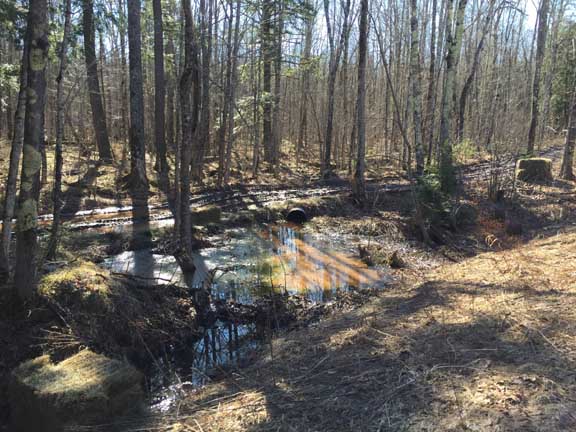
The Michigan DEQ is leading efforts to remedy the erosion -- which was called to their attention by photos taken by Steve Garske, Upper Peninsula Environmental Coalition (UPEC) board member.

Steve Casey, DEQ Water Resources Division district coordinator for the Upper Peninsula, told Keweenaw Now today, Friday, that the photos were emailed to him on Tuesday, Apr. 4. Within a few hours, DEQ staff went out to investigate the site. A press release from UPEC's Mining Action Group was posted shortly afterwards on Apr. 4 with some of the photos.
"Orvana’s exploratory drilling work has turned the site into an ugly, mile-long mudhole," UPEC's press release reported, with the photos as evidence.**
Damage borders (impacts?) Porkies' Presque Isle River Scenic Site
According to Doug Welker, former UPEC board member, the DNR has neglected to enforce stipulations in the state’s Wilderness and Natural Areas law (Part 351) which prohibit mineral exploration in designated State Natural Areas. The land east of the road where the most severe damage has been done is part of the Porcupine Mountains’ Presque Isle River Scenic Site, Welker noted.
"The legal boundary of the Scenic Site is the road itself, not the east boundary of the right-of-way, according to a rule within the Michigan Administrative Code," Welker said. "The Presque Isle River Scenic Site is a legally dedicated State Natural Area, and exploration for or extraction of minerals is prohibited in State Natural Areas according to Michigan law (NREPA)."***

If the road is actually the border of the Presque Isle River Scenic Site, then the state claims of no impact to the park are problematic.
UPDATE: On April 8, after the first posting of this article, John Pepin, DNR deputy public information officer, offered this update the Presque Isle River Scenic Site: "The Gogebic County Road Commission owns County Road 519 and the right-of-way (233 feet on each side of the county road)," Pepin writes. "The Presque Isle River Scenic Site, and other scenic site designations, do not convey ownership. Therefore, the boundary for the scenic site/natural area begins at the edge of the right-of-way. In some instances, the DNR has put some limitations on private land uses, but this is only done in agreement with the property owner. The DNR has no such agreement with the Gogebic County Road Commission."
DEQ staff visit, evaluate site damage
UPEC President Horst Schmidt sent UPEC's press release to Gov. Rick Snyder requesting that the DNR stop the drilling by Highland's contractor in the Porkies.
"We'd already been at the site when the [UPEC] press release came out," Casey said.
Highland Copper had been working on nine bore holes, with a tenth under consideration, along the 519 ROW. With rising temperatures in recent days, the frozen ground where the work was ongoing had begun to thaw quickly, producing mud and water.

The company was accessing the drill sites by driving up and down the snowmobile trail and other access roads near CR 519, Casey added. That is what caused the erosion.
"We observed erosion into a wetland and ditch leading to a tributary to Gipsy Creek," Casey said. "Highland Copper will take immediate steps to stem erosion and they are developing a plan for stabilization of the site."
Casey said that plan will be used to apply for a Soil Erosion and Sedimentation Control Act Permit (Part 91) from Gogebic County. This permit is needed if you disturb the earth within 500 feet of a lake or stream, he explained. The plan must be completed before Highland can apply for this permit.
Highland Copper has employed Coleman Engineering Co., an Upper Peninsula firm, to produce the application and work on getting short- and long-term erosion control measures in place.
Meanwhile, DEQ staff are still evaluating the site for possible wetland violations and assessing the progress on erosion control, Casey noted, though not all wetlands can be delineated this time of year.
"We saw violations of the wetlands statute (Part 303), and we'll be following up on that," he said. "The DEQ and the County enforcing agent will be evaluating the site."
Melanie Humphrey, geological technician for the DEQ Oil, Gas and Mineral Division in Marquette -- who visited the site this week along with Lindsey Ringuette, environmental quality analyst for DEQ Water Resources Division -- said on Apr. 6 that all equipment has been removed from the sites and the holes that were completed have been plugged (cemented).
"We expect records will be submitted once surveys are complete," Humphrey said.
Erosion control is first priority
Anderson inspected the site Wednesday, as drilling rigs were taken down and removed. Personnel were being sent off-site. Highland Copper has also ceased drilling on property it owns west of the state park.


Anderson said at some of the drill sites -- about 100 feet off the blacktop -- the soil is highly disturbed, but there is no off-site migration of sediment or water. At other locations, off the drill pad, or off the immediate drill road, there was liquefied sediment leaving the actual footprint area into either upland forested area or, in some cases, wetland forested area.
However, there was no uncontrolled sediment leaving any of those sites into a stream that goes into the park, Anderson said.
Gogebic County Road Commission Engineer-Manager Darren Pionk said erosion control is the main priority for the short-term.
"Right now, they need to provide some temporary measures to contain erosion on their sites," Pionk said.

Long-term, Highland Copper will take measures, including grading and re-seeding, to permanently restore the area to natural conditions -- a condition of the company’s permit the Gogebic County Road Commission issued Feb. 10, allowing the exploration work.
In answer to some questions on ownership of surface and mineral rights, John Pepin, DNR deputy public information officer, told Keweenaw Now, "Keweenaw Land Association does own the mineral rights under the state land in the park and the ROW and has leased them to Copperwood Resources (formerly Orvana Resources U.S. Corp), which is a subsidiary of Highland Copper -- and the road commission owns the surface property rights."
Under state law, the owner of the minerals has a right to "reasonable" use of the surface to access their minerals.
Work
began on state-managed park land Feb. 3. However, exploration there was
suspended on Feb. 19, due to unseasonably warm late winter
temperatures, after a fourth bore hole was completed.****
"None
of Highland Copper’s exploratory work has since been conducted on state
park land," said John Pepin. "We
visited the work area this week and, along with Highland Copper,
confirmed no impacts
to park land had occurred."
Casey also confirmed that DEQ staff had seen no impacts to the park land from this erosion.
"Based on what we've seen today, there's no damage to the state park land. It's all in the Right of Way," Casey told Keweenaw Now.
If the exploration results indicate the potential for copper in suitable quality and mineable quantities, Highland Copper would conduct a feasibility study, designed to mine the deposit entirely by underground methods, allowing the company to gain access to the copper ore body from land it owns outside the park.
Any potential mining of the minerals would require a separate regulatory process through the DEQ. Highland Copper would have to amend its existing permit.
"The DNR will ensure there would be opportunity for public review and comment before any mining would occur on minerals beneath Porcupine Mountains Wilderness State Park," Pepin said.
Notes:
* Click here for the April 6, 2017, joint press release.
** See the UPEC/Mining Action Group press release here, with links to more photos and documents.
*** Click here for the Part 351 Wilderness and Natural Areas law. Click here and see R 322.27.1 Presque Isle river scenic site on p. 2 of the document.
**** See our Feb. 13, 2017, article, "Environmental coalition objects to DNR permit for exploratory copper drilling in Porcupine Mountains Wilderness State Park."


No comments:
Post a Comment